
Topografische Karte Tangalooma
Klicken Sie auf die Karte, um die Höhe anzuzeigen.
Über diese Karte
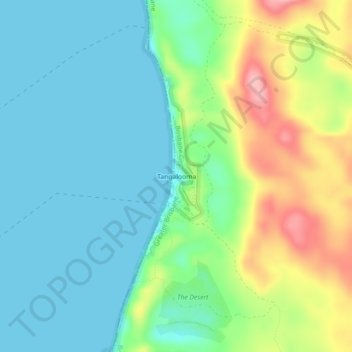
Name: Topografische Karte Tangalooma, Höhe, Relief.
Durchschnittliche Höhe: 41 m
Minimale Höhe: 0 m
Maximale Höhe: 139 m
Andere topografische Karten
Klicken Sie auf eine Karte, um ihre Topografie, ihre Höhe und ihr Relief anzuzeigen.
Mount Coot-tha
Australia > Queensland > City of Brisbane
It is often claimed that Mount Coot-tha is the "highest point in Brisbane", but, as the elevations above show, the peak known as Mount Coot-tha is not even the highest peak of the mountain as a whole with both Constitution Hill and The Summit being higher. However, Mount Coot-tha has a lookout with unobscured…
Durchschnittliche Höhe: 88 m
Deagon
Australia > Queensland > City of Brisbane
Deagon has a flat topography with one of its boundaries being Cabbage Tree Creek. The Creek's catchment is largely urbanised but the Boondall Wetlands, which is separated from Deagon by the Creek, plays an important role in providing essential habitat for a range of birds and animals, including migratory…
Durchschnittliche Höhe: 7 m
Upper Kedron
Australia > Queensland > City of Brisbane
The proposed development responds to the site's topography by offering a range of living options, ranging from bush blocks, to lots designed for terrace-style dwellings.
Durchschnittliche Höhe: 106 m