
Spenden
Topografische Karte Tungkillo
Klicken Sie auf die Karte, um die Höhe anzuzeigen.
Spenden
Tungkillo
Tungkillo (34°49′S 139°04′E / 34.817°S 139.067°E / -34.817; 139.067, postcode 5236, altitude 391m) is a town in South Australia, located approximately 5 km (3.1 mi) south of Mount Pleasant. It sits on Adelaide-Mannum Road, 60 km (37 mi) north-east of the state capital, Adelaide and 25 km (16 mi) north-west of Mannum. At the 2006 census, Tungkillo had a population of 360.
Spenden
Über diese Karte
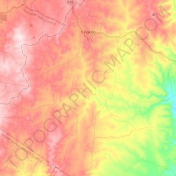
Name: Topografische Karte Tungkillo, Höhe, Relief.
Durchschnittliche Höhe: 373 m
Minimale Höhe: 116 m
Maximale Höhe: 541 m
Spenden
Andere topografische Karten
Klicken Sie auf eine Karte, um ihre Topografie, ihre Höhe und ihr Relief anzuzeigen.
Black Hill
Australia > South Australia > Mid Murray Council > Black Hill
Durchschnittliche Höhe: 108 m
Marne River Mouth
Australia > South Australia > Mid Murray Council > Wongulla
Durchschnittliche Höhe: 32 m