
Topografische Karte Victoria Peak
Interaktive Karte
Klicken Sie auf die Karte, um die Höhe anzuzeigen.
Über diese Karte
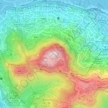
Name: Topografische Karte Victoria Peak, Höhe, Relief.
Ort: Victoria Peak, Hong Kong Island, Hong Kong, China (22.27599 114.14541 22.27609 114.14551)
Durchschnittliche Höhe: 209 m
Minimale Höhe: -2 m
Maximale Höhe: 534 m
Victoria Peak is a hill on the western half of Hong Kong Island. It is also known as Mount Austin, and locally as The Peak only generally. With an elevation of 552 metres (1,811 ft), it is the tallest hill on Hong Kong Island, and the 29th tallest in the territory of Hong Kong. It is a major tourist attraction offering views of Central, Victoria Harbour, Lamma Island and the surrounding islands.
Andere topografische Karten
Klicken Sie auf eine Karte, um ihre Topografie, ihre Höhe und ihr Relief anzuzeigen.
Braemar Hill
China > Hong Kong > Hong Kong Island
Braemar Hill, Hong Kong Island, Hong Kong, 000000, China
Durchschnittliche Höhe: 89 m
Pok Fu Lam Reservoir
China > Hong Kong > Hong Kong Island
Pok Fu Lam Reservoir, Telegraph Bay, Pok Fu Lam, Southern District, Hong Kong Island, Hong Kong, China
Durchschnittliche Höhe: 192 m
Tai Tam Mound Waterfall
China > Hong Kong > Hong Kong Island
Tai Tam Mound Waterfall, Southern District, Hong Kong Island, Hong Kong, China
Durchschnittliche Höhe: 150 m
Wong Chuk Hang San Wai
China > Hong Kong > Hong Kong Island > Wong Chuk Hang San Wai
Wong Chuk Hang San Wai, Southern District, Hong Kong Island, Hong Kong, China
Durchschnittliche Höhe: 116 m
Sai Wan
China > Hong Kong > Hong Kong Island
Sai Wan, Central and Western District, Hong Kong Island, Hong Kong, China
Durchschnittliche Höhe: 81 m
Southern District
China > Hong Kong > Hong Kong Island
Southern District, Hong Kong Island, Hong Kong, China
Durchschnittliche Höhe: 36 m
Victoria Park
China > Hong Kong > Hong Kong Island
Victoria Park, Causeway Bay, Wan Chai District, Hong Kong Island, Hong Kong, China
Durchschnittliche Höhe: 64 m