
Topografische Karte Bossier City
Interaktive Karte
Klicken Sie auf die Karte, um die Höhe anzuzeigen.
Über diese Karte
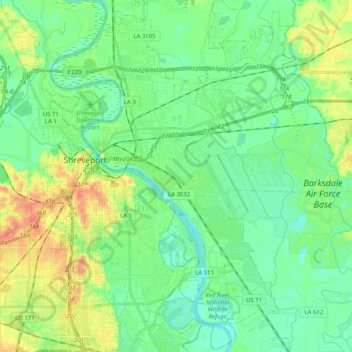
Name: Topografische Karte Bossier City, Höhe, Relief.
Ort: Bossier City, Bossier Parish, Louisiana, United States (32.41979 -93.74928 32.59081 -93.58433)
Durchschnittliche Höhe: 55 m
Minimale Höhe: 40 m
Maximale Höhe: 85 m
Bossier City is located at 32°31′4″N 93°41′29″W / 32.51778°N 93.69139°W / 32.51778; -93.69139 (32.517651, −93.691397) within the Ark-La-Tex and has an elevation of 174 feet (53.0 m) above sea level. The city lies primarily on the banks of the Red River, and has a largely flat topography in contrast with Shreveport's terrain. The northern city limits are noticeably more hilly than the rest of the city. Many small waterways flow through the city, such as Flat River and Red Chute Bayou, which provide drainage for many areas of the city.
Andere topografische Karten
Klicken Sie auf eine Karte, um ihre Topografie, ihre Höhe und ihr Relief anzuzeigen.
Waller
United States > Louisiana > Bossier Parish > Bossier City
Waller, Bossier City, Bossier Parish, Louisiana, 71171, United States
Durchschnittliche Höhe: 53 m
Fillmore
United States > Louisiana > Bossier Parish
Fillmore, Bossier Parish, Louisiana, 71067, United States
Durchschnittliche Höhe: 81 m
Bossier City
United States > Louisiana > Bossier Parish
Bossier City, Bossier Parish, Louisiana, United States
Durchschnittliche Höhe: 55 m
Benton
United States > Louisiana > Bossier Parish
Benton, Bossier Parish, Louisiana, United States
Durchschnittliche Höhe: 62 m
Plain Dealing
United States > Louisiana > Bossier Parish
Plain Dealing, Bossier Parish, Louisiana, 71064, United States
Durchschnittliche Höhe: 93 m
Alden Bridge
United States > Louisiana > Bossier Parish
Alden Bridge, Bossier Parish, Louisiana, United States
Durchschnittliche Höhe: 69 m