
Vielen Dank für die Unterstützung dieser Website ❤️
Spenden
Spenden
Topografische Karte Sant Pere de Vilamajor
Klicken Sie auf die Karte, um die Höhe anzuzeigen.
Vielen Dank für die Unterstützung dieser Website ❤️
Spenden
Spenden
Über diese Karte
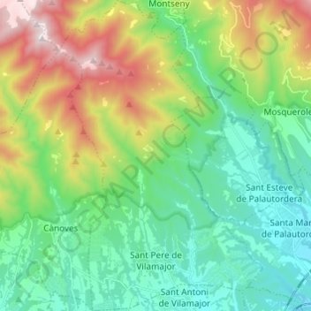
Name: Topografische Karte Sant Pere de Vilamajor, Höhe, Relief.
Durchschnittliche Höhe: 522 m
Minimale Höhe: 182 m
Maximale Höhe: 1.312 m
Vielen Dank für die Unterstützung dieser Website ❤️
Spenden
Spenden
Andere topografische Karten
Klicken Sie auf eine Karte, um ihre Topografie, ihre Höhe und ihr Relief anzuzeigen.
Corró d'Amunt
Spain > Catalonia > Vallès Oriental > les Franqueses del Vallès
Durchschnittliche Höhe: 287 m
les Agudes
Spain > Catalonia > Vallès Oriental > Montseny
Les Agudes is a mountain of Catalonia, Spain. It has an elevation of 1,706 metres (5,597 ft) above sea level. It is straddling the municipalities of Arbúcies in the Selva comarca and Fogars de Montclús and Montseny in the Vallès Oriental.
Durchschnittliche Höhe: 1.288 m
Vielen Dank für die Unterstützung dieser Website ❤️
Spenden
Spenden