Geolokalisieren
👉 Easily get elevation data in JSON, GeoTIFF and KML formats using Elevation API
Vielen Dank für die Unterstützung dieser Website ❤️
Spenden

Topografische Karte Aubeterre-sur-Dronne

Klicken Sie auf die Karte, um die Höhe anzuzeigen.

👉 Easily get elevation data in JSON, GeoTIFF and KML formats using Elevation API
Vielen Dank für die Unterstützung dieser Website ❤️
Spenden

Aubeterre-sur-Dronne

The highest point of the commune is at an altitude of 111m and is located on the plateau near the northern boundary. The lowest point is 38m located on the southern boundary next to the Dronne. The commune is spread between the valley of the Dronne and the top of the hill.

Wikipedia (CC-BY-SA 3.0)

👉 Easily get elevation data in JSON, GeoTIFF and KML formats using Elevation API
Vielen Dank für die Unterstützung dieser Website ❤️
Spenden

Über diese Karte

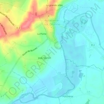
Name: Topografische Karte Aubeterre-sur-Dronne, Höhe, Relief.

Ort: Aubeterre-sur-Dronne, Angoulême, Charente, Nouvelle-Aquitaine, Metropolitan France, 16390, France (45.25157 0.15494 45.27552 0.17809)

Durchschnittliche Höhe: 60 m

Minimale Höhe: 38 m

Maximale Höhe: 119 m

👉 Easily get elevation data in JSON, GeoTIFF and KML formats using Elevation API
Vielen Dank für die Unterstützung dieser Website ❤️
Spenden

Andere topografische Karten

Klicken Sie auf eine Karte, um ihre Topografie, ihre Höhe und ihr Relief anzuzeigen.

Rocher aux oiseaux

France > Nouvelle-Aquitaine > Charente > Montrollet

Durchschnittliche Höhe: 317 m

la Pouillargues

France > Nouvelle-Aquitaine > Charente > Juignac

Durchschnittliche Höhe: 143 m

Margnac

France > Nouvelle-Aquitaine > Charente > Vitrac-Saint-Vincent

Durchschnittliche Höhe: 173 m

Vielen Dank für die Unterstützung dieser Website ❤️
Spenden

Les Chaudroles

France > Nouvelle-Aquitaine > Charente > Val-de-Cognac

Durchschnittliche Höhe: 40 m

Cors

France > Nouvelle-Aquitaine > Charente > Foussignac

Durchschnittliche Höhe: 85 m

La Pallue

France > Nouvelle-Aquitaine > Charente > Gensac-la-Pallue

Durchschnittliche Höhe: 24 m

Basset

France > Nouvelle-Aquitaine > Charente > Juignac

Durchschnittliche Höhe: 144 m

Vielen Dank für die Unterstützung dieser Website ❤️
Spenden

Les Gillardes

France > Nouvelle-Aquitaine > Charente > Bioussac

Durchschnittliche Höhe: 118 m

Yvrac

France > Nouvelle-Aquitaine > Charente > Yvrac-et-Malleyrand

Durchschnittliche Höhe: 152 m

Vielen Dank für die Unterstützung dieser Website ❤️
Spenden

Verina

France > Nouvelle-Aquitaine > Charente > Lesterps

Durchschnittliche Höhe: 248 m

Dizedon

France > Nouvelle-Aquitaine > Charente > Châteaubernard

Durchschnittliche Höhe: 20 m

Mauberge

France > Nouvelle-Aquitaine > Charente > Hiersac

Durchschnittliche Höhe: 80 m

Fontafie

France > Nouvelle-Aquitaine > Charente

Durchschnittliche Höhe: 189 m

Vielen Dank für die Unterstützung dieser Website ❤️
Spenden

Boutiers

France > Nouvelle-Aquitaine > Charente > Boutiers-Saint-Trojan

Durchschnittliche Höhe: 21 m

Le Maine

France > Nouvelle-Aquitaine > Charente > Champniers

Durchschnittliche Höhe: 72 m

La Broue

France > Nouvelle-Aquitaine > Charente > Saint-Gourson

Durchschnittliche Höhe: 124 m

Servolles

France > Nouvelle-Aquitaine > Charente > Massignac

Durchschnittliche Höhe: 249 m

Vielen Dank für die Unterstützung dieser Website ❤️
Spenden

Pairs

France > Nouvelle-Aquitaine > Charente > Saint-Christophe

Durchschnittliche Höhe: 264 m

Les Cossardières

France > Nouvelle-Aquitaine > Charente

Durchschnittliche Höhe: 245 m