
Vielen Dank für die Unterstützung dieser Website ❤️
Spenden
Spenden
Topografische Karte Gavhali Tanda
Klicken Sie auf die Karte, um die Höhe anzuzeigen.
Vielen Dank für die Unterstützung dieser Website ❤️
Spenden
Spenden
Über diese Karte
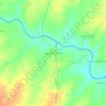
Name: Topografische Karte Gavhali Tanda, Höhe, Relief.
Ort: Gavhali Tanda, Sillod, Aurangabad, Maharashtra, India (20.20477 75.65866 20.24477 75.69866)
Durchschnittliche Höhe: 587 m
Minimale Höhe: 568 m
Maximale Höhe: 608 m
Vielen Dank für die Unterstützung dieser Website ❤️
Spenden
Spenden