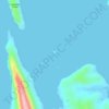
Topografische Karte Mandaon
Klicken Sie auf die Karte, um die Höhe anzuzeigen.
Mandaon
Mandaon was originally a barrio of Milagros, established by Barrio Lieutenant Feliciano Aquillo Sr. In 1948, Juan Valencia, a settler from Pampanga, advocated for its elevation into a municipality. On July 18, 1949, President Elpidio Quirino, through Executive Order No. 244, officially recognized Mandaon as an independent municipality, distinct from Milagros.
Über diese Karte

Name: Topografische Karte Mandaon, Höhe, Relief.
Ort: Mandaon, Masbate, Bicol Region, 5411, Philippines (12.18665 123.24491 12.26665 123.32491)
Durchschnittliche Höhe: 18 m
Minimale Höhe: -2 m
Maximale Höhe: 168 m
Andere topografische Karten
Klicken Sie auf eine Karte, um ihre Topografie, ihre Höhe und ihr Relief anzuzeigen.



Jintotolo Island
Philippines > Masbate > Jintotolo
Its elevation was recorded at around 120 feet (37 m) in 1919. A lighthouse with a tower at 51 feet (16 m) in height exists on Jintotolo island.
Durchschnittliche Höhe: 6 m