Geolokalisieren
👉 Easily get elevation data in JSON, GeoTIFF and KML formats using Elevation API
Vielen Dank für die Unterstützung dieser Website ❤️
Spenden

Topografische Karte Tulang

Klicken Sie auf die Karte, um die Höhe anzuzeigen.

👉 Easily get elevation data in JSON, GeoTIFF and KML formats using Elevation API
Vielen Dank für die Unterstützung dieser Website ❤️
Spenden

Über diese Karte

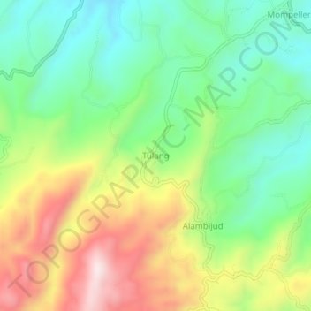
Name: Topografische Karte Tulang, Höhe, Relief.

Ort: Tulang, Cebu, Central Visayas, Philippines (9.94076 123.49168 9.98076 123.53168)

Durchschnittliche Höhe: 398 m

Minimale Höhe: 196 m

Maximale Höhe: 709 m

👉 Easily get elevation data in JSON, GeoTIFF and KML formats using Elevation API
Vielen Dank für die Unterstützung dieser Website ❤️
Spenden

Andere topografische Karten

Klicken Sie auf eine Karte, um ihre Topografie, ihre Höhe und ihr Relief anzuzeigen.

Moalboal

Philippines > Cebu > Moalboal

Durchschnittliche Höhe: 13 m

Pacijan Island

Philippines > Cebu > San Francisco

Durchschnittliche Höhe: 22 m

Poro

Philippines > Cebu

Durchschnittliche Höhe: 12 m

Mactan

Philippines > Cebu > Lapu-Lapu

Durchschnittliche Höhe: 3 m

Vielen Dank für die Unterstützung dieser Website ❤️
Spenden

Oslob

Philippines > Cebu

Generally, topography of the area is hilly and rolling, dominated by open grasslands and second growth forest. There are fairly level and rolling plateaus and valleys spread throughout the interior. These are some of the most suitable areas for upland agriculture. The highest mountain peak is 800 metres (2,600…

Durchschnittliche Höhe: 99 m

Pilar

Philippines > Cebu > Pilar

Durchschnittliche Höhe: 9 m

Bantayan Island

Philippines > Cebu > Obo-ob

Durchschnittliche Höhe: 5 m

Toledo City Plaza

Philippines > Cebu > Toledo

Durchschnittliche Höhe: 9 m

Vielen Dank für die Unterstützung dieser Website ❤️
Spenden