
Spenden
Topografische Karte Silverthrone Mountain
Klicken Sie auf die Karte, um die Höhe anzuzeigen.
Spenden
Silverthrone Mountain
Mount Silverthrone is perhaps one of the most heavily is perhaps one of the most heavily glaciated volcanic peaks in southwestern British Columbia. It has a topographic prominence of approximately 975 m (3,200 ft), greater than any other volcano in southwestern British Columbia. The extensive icefields around Mount Silverthrone are receding and are small compared to their former extent, but they are an impressive indication of how much of British Columbia looked 10,000 years or more ago. Silverthrone contains one of the few calderas buried beneath the ice caps of western Canada, another example being Mount Edziza in far northwestern British Columbia.
Spenden
Über diese Karte
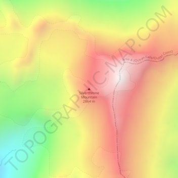
Name: Topografische Karte Silverthrone Mountain, Höhe, Relief.
Durchschnittliche Höhe: 2.297 m
Minimale Höhe: 1.809 m
Maximale Höhe: 2.835 m
Spenden
Andere topografische Karten
Klicken Sie auf eine Karte, um ihre Topografie, ihre Höhe und ihr Relief anzuzeigen.
Mistake Island
Canada > British Columbia > Regional District of Mount Waddington > Area A (Seymour Inlet/Knight Inlet)
Durchschnittliche Höhe: 24 m
Mayor Island
Canada > British Columbia > Regional District of Mount Waddington > Area A (Seymour Inlet/Knight Inlet)
Durchschnittliche Höhe: 5 m
Malcolm Island
Canada > British Columbia > Regional District of Mount Waddington > Area A (Seymour Inlet/Knight Inlet)
Durchschnittliche Höhe: 21 m
Kingcome Inlet
Canada > British Columbia > Regional District of Mount Waddington > Area A (Seymour Inlet/Knight Inlet)
Durchschnittliche Höhe: 305 m
Spenden