Geolokalisieren
👉 Easily get elevation data in JSON, GeoTIFF and KML formats using Elevation API
Vielen Dank für die Unterstützung dieser Website ❤️
Spenden

Topografische Karte Eure

Klicken Sie auf die Karte, um die Höhe anzuzeigen.

👉 Easily get elevation data in JSON, GeoTIFF and KML formats using Elevation API
Vielen Dank für die Unterstützung dieser Website ❤️
Spenden

Eure

D'une altitude moyenne de 150 mètres, l'Eure est un département constitué de plateaux séparés par des vallées plus ou moins profondes. Celles-ci délimitent les différentes régions naturelles qui sont au nombre de 13 : le pays de Lyons, le Vexin normand, le Vexin bossu, la vallée de la Seine, le plateau de Madrie, la campagne de Saint-André, le plateau du Neubourg, le pays d'Ouche (partagé avec l'Orne), le Roumois, le Lieuvin, le Marais-Vernier, le pays d'Auge (partagé avec le Calvados et l'Orne) et un petit secteur du Perche, qui se prolonge dans les départements d'Eure-et-Loir et de l'Orne.

Wikipedia (CC-BY-SA 3.0)

👉 Easily get elevation data in JSON, GeoTIFF and KML formats using Elevation API
Vielen Dank für die Unterstützung dieser Website ❤️
Spenden

Über diese Karte

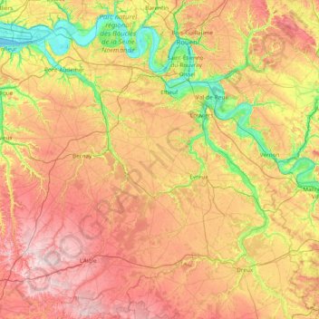
Name: Topografische Karte Eure, Höhe, Relief.

Ort: Eure, Normandie, France métropolitaine, France (48.66642 0.29616 49.48482 1.80286)

Durchschnittliche Höhe: 141 m

Minimale Höhe: -3 m

Maximale Höhe: 331 m

👉 Easily get elevation data in JSON, GeoTIFF and KML formats using Elevation API
Vielen Dank für die Unterstützung dieser Website ❤️
Spenden

Andere topografische Karten

Klicken Sie auf eine Karte, um ihre Topografie, ihre Höhe und ihr Relief anzuzeigen.

Le Havre

France > Normandie > Seine-Maritime > Le Havre

Le Havre appartient à l'ensemble géologique du Bassin parisien, formé à l'ère secondaire. Ce dernier se compose de roches sédimentaires. La commune du Havre se compose de deux ensembles naturels séparés par une « falaise morte » ou « côte » : la ville basse, au sud, et la ville haute, au nord. La…

Durchschnittliche Höhe: 37 m

Pirou-Plage

France > Normandie > Manche

Durchschnittliche Höhe: 5 m

Le Pont Gaché

France > Normandie > Manche > Gavray-sur-Sienne > Gavray

Durchschnittliche Höhe: 77 m

Saint-Martin

France > Normandie > Manche > Montbray

Durchschnittliche Höhe: 162 m

Vielen Dank für die Unterstützung dieser Website ❤️
Spenden

Mont Saint-Michel

France > Normandie > Manche > Le Mont-Saint-Michel

Le mont baigne dans la baie du Mont-Saint-Michel, ouverte sur la Manche et s’élève dans une grande plaine sablonneuse. L’îlot atteint 92 mètres d’altitude et offre une superficie émergée d’environ 7 ha, la partie essentielle du rocher étant couverte par l’emprise au sol de l’abbaye du…

Durchschnittliche Höhe: 2 m

Les Rouges Verts

France > Normandie > Orne > Sévigny

Durchschnittliche Höhe: 199 m

Les Basses Folletières

France > Normandie > Orne > Flers

Durchschnittliche Höhe: 224 m

Vielen Dank für die Unterstützung dieser Website ❤️
Spenden

La Rabotière

France > Normandie > Calvados > Martainville

Durchschnittliche Höhe: 196 m

La Gare

France > Normandie > Manche > Lithaire

Durchschnittliche Höhe: 60 m

Village Talfaret

France > Normandie > Manche > Couville

Durchschnittliche Höhe: 94 m

La Roulandière

France > Normandie > Manche > Cerisy-la-Salle

Durchschnittliche Höhe: 117 m

Vielen Dank für die Unterstützung dieser Website ❤️
Spenden

Jonville

France > Normandie > Manche > Réville

Durchschnittliche Höhe: 2 m

La Ventinière

France > Normandie > Manche > Marchésieux

Durchschnittliche Höhe: 10 m

Cambercourt

France > Normandie > Orne > Berjou

Durchschnittliche Höhe: 161 m

Villa Sayer

France > Normandie > Calvados > Glanville > Lieu Émisse

Durchschnittliche Höhe: 96 m

Vielen Dank für die Unterstützung dieser Website ❤️
Spenden

Les Hazes

France > Normandie > Orne > Écouché-les-Vallées

Durchschnittliche Höhe: 162 m

La Cauvinière

France > Normandie > Manche > Hébécrevon

Durchschnittliche Höhe: 59 m

Hameau Clapet

France > Normandie > Manche > Pierreville

Durchschnittliche Höhe: 75 m

Le Haut Candol

France > Normandie > Manche > Saint-Lô

Durchschnittliche Höhe: 48 m

Vielen Dank für die Unterstützung dieser Website ❤️
Spenden

Le Haut des Cours

France > Normandie > Seine-Maritime > Norville

Durchschnittliche Höhe: 42 m

Le Hameau Sauvage

France > Normandie > Manche > La Hague > Beaumont-Hague

Durchschnittliche Höhe: 131 m

La Fosserie

France > Normandie > Manche > Coutances

Durchschnittliche Höhe: 95 m

Joyeux

France > Normandie > Seine-Maritime > Ypreville-Biville

Durchschnittliche Höhe: 124 m

Vielen Dank für die Unterstützung dieser Website ❤️
Spenden

La Vallée

France > Normandie > Calvados > Mutrécy

Durchschnittliche Höhe: 72 m

Hameau Gilles

France > Normandie > Manche > Anneville-en-Saire

Durchschnittliche Höhe: 9 m

Château de Saint-Germain

France > Normandie > Calvados > Marolles

Durchschnittliche Höhe: 150 m

Vielen Dank für die Unterstützung dieser Website ❤️
Spenden

Les Basses Planches

France > Normandie > Calvados > Saint-Omer

Durchschnittliche Höhe: 185 m

Le Pont de la Mousse

France > Normandie > Calvados > Saint-Rémy

Durchschnittliche Höhe: 100 m

Le Melleret

France > Normandie > Manche > Bricquebec-en-Cotentin > Bricquebec

Durchschnittliche Höhe: 57 m

Vielen Dank für die Unterstützung dieser Website ❤️
Spenden

Domfront

France > Normandie > Orne > Domfront en Poiraie

Durchschnittliche Höhe: 166 m

Les Loges

France > Normandie > Eure > Écaquelon

Durchschnittliche Höhe: 118 m

Le Moulin à Vent

France > Normandie > Orne > Les Menus

Durchschnittliche Höhe: 220 m

Le Val de May

France > Normandie > Calvados > Saint-Martin-de-May > May-sur-Orne

Durchschnittliche Höhe: 49 m

Vielen Dank für die Unterstützung dieser Website ❤️
Spenden

Hameau du Cap Lévi

France > Normandie > Manche > Fermanville

Durchschnittliche Höhe: 15 m

La Petite Mortrée

France > Normandie > Orne > Mortrée

Durchschnittliche Höhe: 186 m

Crèvecœur

France > Normandie > Eure > Clef-Vallée-d'Eure

Durchschnittliche Höhe: 77 m

Pressagny-le-Val

France > Normandie > Eure > Notre-Dame-de-l'Isle

Durchschnittliche Höhe: 85 m

Vielen Dank für die Unterstützung dieser Website ❤️
Spenden

Boisgeloup

France > Normandie > Eure > Gisors

Durchschnittliche Höhe: 88 m

La Houleterie

France > Normandie > Eure > Caumont

Durchschnittliche Höhe: 93 m

La Palaserie

France > Normandie > Orne > Pouvrai

Durchschnittliche Höhe: 131 m

Les Hauts Vents

France > Normandie > Manche > Tessy-Bocage

Durchschnittliche Höhe: 104 m

Vielen Dank für die Unterstützung dieser Website ❤️
Spenden

La Brique

France > Normandie > Manche > Saint-Joseph

Durchschnittliche Höhe: 51 m

Fumichon

France > Normandie > Calvados > Neuilly-la-Forêt

Durchschnittliche Höhe: 17 m

Le Souci

France > Normandie > Orne > Charencey

Durchschnittliche Höhe: 224 m

Les Moulins

France > Normandie > Manche > Barneville-Carteret

Durchschnittliche Höhe: 32 m

Vielen Dank für die Unterstützung dieser Website ❤️
Spenden

Les Mariaux

France > Normandie > Eure > Bois-Arnault

Durchschnittliche Höhe: 204 m

Saint-Georges

France > Normandie > Orne > Pontchardon

Durchschnittliche Höhe: 183 m

Sérigny

France > Normandie > Orne

Durchschnittliche Höhe: 196 m

Le Hamel

France > Normandie > Manche > Condé-sur-Vire > Les Carrières

Durchschnittliche Höhe: 51 m

Vielen Dank für die Unterstützung dieser Website ❤️
Spenden

Secqueville

France > Normandie > Calvados > Le Castelet > Garcelles-Secqueville

Durchschnittliche Höhe: 65 m

Autrebosc

France > Normandie > Eure > Tourneville

Durchschnittliche Höhe: 117 m

Les Grandies

France > Normandie > Manche > Sainte-Marie-du-Mont

Durchschnittliche Höhe: 7 m

La Jeannerie

France > Normandie > Manche > Blainville-sur-Mer

Durchschnittliche Höhe: 29 m

Vielen Dank für die Unterstützung dieser Website ❤️
Spenden

Le Haras

France > Normandie > Manche > Picauville

Durchschnittliche Höhe: 17 m

Hameau de Haut

France > Normandie > Manche > Les Moitiers-en-Bauptois

Durchschnittliche Höhe: 15 m

Fée

France > Normandie > Orne > Ceton

Durchschnittliche Höhe: 144 m

La Moisière

France > Normandie > Orne > Bonsmoulins

Durchschnittliche Höhe: 250 m

Vielen Dank für die Unterstützung dieser Website ❤️
Spenden

Saint Germain-De-Loisé

France > Normandie > Orne > Mortagne-au-Perche

Durchschnittliche Höhe: 210 m

Le Hardelle

France > Normandie > Manche > Bretteville

Durchschnittliche Höhe: 50 m

Le Launay

France > Normandie > Calvados > Aurseulles

Durchschnittliche Höhe: 126 m

Mont Canisy

France > Normandie > Calvados > Benerville-sur-Mer

Durchschnittliche Höhe: 41 m

Vielen Dank für die Unterstützung dieser Website ❤️
Spenden

La Sentelle

France > Normandie > Eure > Mesnil-en-Ouche > La Roussière

Durchschnittliche Höhe: 192 m

Gouville

France > Normandie > Eure > Mesnils-sur-Iton

Durchschnittliche Höhe: 164 m

La Ferme des Sapins

France > Normandie > Seine-Maritime > Yport

Durchschnittliche Höhe: 65 m

Le Grand Samoi

France > Normandie > Orne > Saint-Pierre-du-Regard

Durchschnittliche Höhe: 139 m

Vielen Dank für die Unterstützung dieser Website ❤️
Spenden

Le Frechot

France > Normandie > Manche > Le Grand-Celland

Durchschnittliche Höhe: 177 m

Écambosc

France > Normandie > Eure > Quittebeuf

Durchschnittliche Höhe: 142 m

La Maillardière

France > Normandie > Orne > Montilly-sur-Noireau

Durchschnittliche Höhe: 128 m

Bellevue

France > Normandie > Seine-Maritime > Saint-Jacques-sur-Darnétal

Durchschnittliche Höhe: 148 m

Vielen Dank für die Unterstützung dieser Website ❤️
Spenden

Le Mesnil

France > Normandie > Eure > Acon

Durchschnittliche Höhe: 160 m

Les Ervolus

France > Normandie > Eure > Le Plessis-Grohan

Durchschnittliche Höhe: 145 m

La Saussaie

France > Normandie > Orne > Bretoncelles

Durchschnittliche Höhe: 161 m

La Cinquantaine

France > Normandie > Calvados > Blonville-sur-Mer

Durchschnittliche Höhe: 29 m

Vielen Dank für die Unterstützung dieser Website ❤️
Spenden

Le Bout du Bas

France > Normandie > Seine-Maritime > Offranville

Durchschnittliche Höhe: 74 m

Fort Fresnay

France > Normandie > Orne > Fresnay-le-Samson

Durchschnittliche Höhe: 175 m

La Dandière

France > Normandie > Orne > Sainte-Honorine-la-Guillaume

Durchschnittliche Höhe: 216 m

La Bunodière

France > Normandie > Orne > Athis-Val-de-Rouvre > Athis-de-l'Orne

Durchschnittliche Höhe: 218 m

Vielen Dank für die Unterstützung dieser Website ❤️
Spenden

Le Mont Martin

France > Normandie > Eure > Gaillon

Durchschnittliche Höhe: 85 m

Plage de St Adresse

France > Normandie > Seine-Maritime > Le Havre

Durchschnittliche Höhe: 40 m

Longueville

France > Normandie > Calvados > Ranville

Durchschnittliche Höhe: 18 m

Huanville

France > Normandie > Manche > Port-Bail-sur-Mer > Saint-Lô-d'Ourville

Durchschnittliche Höhe: 30 m

Vielen Dank für die Unterstützung dieser Website ❤️
Spenden

Manoir de Méterville

France > Normandie > Manche > Gorges > La Scellerie

Durchschnittliche Höhe: 13 m

Le Pont de Vie

France > Normandie > Orne > Vimoutiers

Durchschnittliche Höhe: 165 m

Groussey

France > Normandie > Manche > Jullouville

Durchschnittliche Höhe: 45 m

La Bretonne

France > Normandie > Manche > Barfleur

Durchschnittliche Höhe: 6 m

Vielen Dank für die Unterstützung dieser Website ❤️
Spenden

Étang de la Visance

France > Normandie > Orne > Chanu

Durchschnittliche Höhe: 254 m

La Millerette

France > Normandie > Eure > Sylvains-lès-Moulins

Durchschnittliche Höhe: 150 m

Le Poiré

France > Normandie > Manche > Morville

Durchschnittliche Höhe: 30 m

La Garenne

France > Normandie > Calvados > Benerville-sur-Mer

Durchschnittliche Höhe: 21 m

Vielen Dank für die Unterstützung dieser Website ❤️
Spenden

Les Hauts Vents

France > Normandie > Manche > Bricqueville-sur-Mer

Durchschnittliche Höhe: 44 m

Le Hameau du Broquet

France > Normandie > Manche > Teurthéville-Bocage

Durchschnittliche Höhe: 69 m

Saint-Siméon

France > Normandie > Manche > Port-Bail-sur-Mer > Portbail

Durchschnittliche Höhe: 20 m

Vielen Dank für die Unterstützung dieser Website ❤️
Spenden

La Poterie

France > Normandie > Manche > Lengronne

Durchschnittliche Höhe: 97 m

Bois Giffard

France > Normandie > Seine-Maritime > Bolbec > La Maison Blanche

Durchschnittliche Höhe: 127 m

Conchez

France > Normandie > Eure

Durchschnittliche Höhe: 140 m

Le Saussey

France > Normandie > Manche > La Hague > Flottemanville-Hague

Durchschnittliche Höhe: 114 m

Vielen Dank für die Unterstützung dieser Website ❤️
Spenden