
Topografische Karte Richmond County
Interaktive Karte
Klicken Sie auf die Karte, um die Höhe anzuzeigen.
Über diese Karte
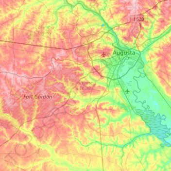
Name: Topografische Karte Richmond County, Höhe, Relief.
Ort: Richmond County, Georgia, United States (33.22717 -82.35387 33.54502 -81.82812)
Durchschnittliche Höhe: 96 m
Minimale Höhe: 22 m
Maximale Höhe: 177 m
Andere topografische Karten
Klicken Sie auf eine Karte, um ihre Topografie, ihre Höhe und ihr Relief anzuzeigen.
Augusta Canal
United States > Georgia > Richmond County > Augusta
Augusta Canal, Augusta, Richmond County, Georgia, United States
Durchschnittliche Höhe: 80 m
Dorchester
United States > Georgia > Richmond County > Augusta
Dorchester, Augusta, Richmond County, Georgia, 30909, United States
Durchschnittliche Höhe: 90 m
Forest Acres
United States > Georgia > Richmond County > Augusta
Forest Acres, Augusta, Richmond County, Georgia, 30904, United States
Durchschnittliche Höhe: 67 m
Fairvale
United States > Georgia > Richmond County > Augusta
Fairvale, Augusta, Richmond County, Georgia, 30906, United States
Durchschnittliche Höhe: 56 m
Ellwood
United States > Georgia > Richmond County > Augusta
Ellwood, Augusta, Richmond County, Georgia, United States
Durchschnittliche Höhe: 119 m
Berckman Villas
United States > Georgia > Richmond County > Augusta > Berckman Villas
Berckman Villas, Augusta, Richmond County, Georgia, 30904, United States
Durchschnittliche Höhe: 87 m
Fort Gordon
United States > Georgia > Richmond County > Augusta > Fort Gordon
Fort Gordon, Augusta, Richmond County, Georgia, 30905, United States
Durchschnittliche Höhe: 136 m
Augusta
United States > Georgia > Richmond County
Augusta, Richmond County, Georgia, United States
Durchschnittliche Höhe: 89 m