
Topografische Karte Anshan
Interaktive Karte
Klicken Sie auf die Karte, um die Höhe anzuzeigen.
Über diese Karte
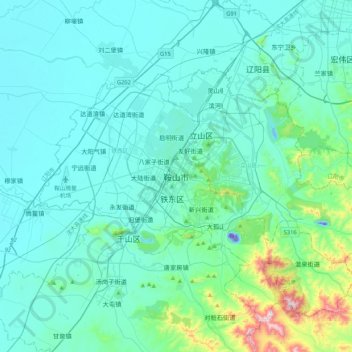
Name: Topografische Karte Anshan, Höhe, Relief.
Durchschnittliche Höhe: 79 m
Minimale Höhe: -53 m
Maximale Höhe: 667 m
Local transportation is primarily by bus or taxi. Anshan used to have a single tram line—along Zhonghua Avenue, through the city centre and past Angang main gate—but this has been closed and the tracks removed. Due to the flat topography of the city centre, bicycles are popular. Almost all roads have a wide cycle lane on each side. Often this lane is further protected by a traffic island that separates the bikes from larger motor vehicles.