
Spenden
Topografische Karte Mozarlândia
Klicken Sie auf die Karte, um die Höhe anzuzeigen.
Spenden
Mozarlândia
The main rivers that bathe the municipality are the Rio Tesouras and Rio do Peixe, besides the streams (córregos) of Alagadinho, Alagado, São João, Fogueira, Barreirinho, do Gato, Lagoinha, do Buriti, do Manoel and Muquém. Because of the flat topography near the main rivers, there are places that have a rich formation in lakes: Landi, Lolito, Pedra, Correia, da Onça, da Mãe, Redondo, Cabaça and many others. The mountains that stand out are Constantino, Pimenta, Pouso Alto, Jiripoca, Tombador and Bananal and the hills of São João and Engano.
Spenden
Über diese Karte
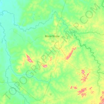
Name: Topografische Karte Mozarlândia, Höhe, Relief.
Durchschnittliche Höhe: 300 m
Minimale Höhe: 235 m
Maximale Höhe: 557 m
Spenden
Andere topografische Karten
Klicken Sie auf eine Karte, um ihre Topografie, ihre Höhe und ihr Relief anzuzeigen.
Spenden
Rosa
Brazil > Goiás > Região Integrada de Desenvolvimento do Distrito Federal e Entorno > Pirenópolis
Durchschnittliche Höhe: 780 m
Bom Jesus
Brazil > Goiás > Região Integrada de Desenvolvimento do Distrito Federal e Entorno > Pirenópolis
Durchschnittliche Höhe: 760 m
Spenden
Rio Arraial Velho
Brazil > Goiás > Região Integrada de Desenvolvimento do Distrito Federal e Entorno > Água Fria de Goiás
Durchschnittliche Höhe: 847 m
Paiol Velho
Brazil > Goiás > Região Integrada de Desenvolvimento do Distrito Federal e Entorno > Pirenópolis
Durchschnittliche Höhe: 730 m