
Vielen Dank für die Unterstützung dieser Website ❤️
Spenden
Spenden
Topografische Karte Spottswood
Klicken Sie auf die Karte, um die Höhe anzuzeigen.
Vielen Dank für die Unterstützung dieser Website ❤️
Spenden
Spenden
Über diese Karte
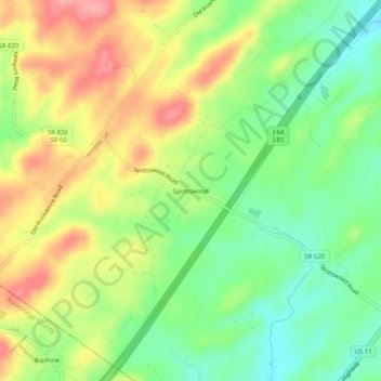
Name: Topografische Karte Spottswood, Höhe, Relief.
Ort: Spottswood, Augusta County, Virginia, 24475, United States (37.93513 -79.23364 37.97513 -79.19364)
Durchschnittliche Höhe: 568 m
Minimale Höhe: 517 m
Maximale Höhe: 631 m
Vielen Dank für die Unterstützung dieser Website ❤️
Spenden
Spenden
Andere topografische Karten
Klicken Sie auf eine Karte, um ihre Topografie, ihre Höhe und ihr Relief anzuzeigen.
Vielen Dank für die Unterstützung dieser Website ❤️
Spenden
Spenden
Stuarts Draft
United States > Virginia > Augusta County
Stuarts Draft includes several natural and man-made ponds. Lake Wilda is Green Pond is a naturally occurring high-elevation pond on the Big Levels Ridge. It is five acres in size during the wet season. The Virginia Commission of Game and Inland Fisheries constructed the Maple Flats Ponds in the late 1950s to…
Durchschnittliche Höhe: 457 m
Vielen Dank für die Unterstützung dieser Website ❤️
Spenden
Spenden