
Topografische Karte Edgewood
Interaktive Karte
Klicken Sie auf die Karte, um die Höhe anzuzeigen.
Über diese Karte
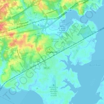
Name: Topografische Karte Edgewood, Höhe, Relief.
Ort: Edgewood, Harford County, Maryland, 21040, United States (39.37872 -76.33440 39.45872 -76.25440)
Durchschnittliche Höhe: 12 m
Minimale Höhe: -4 m
Maximale Höhe: 61 m
Andere topografische Karten
Klicken Sie auf eine Karte, um ihre Topografie, ihre Höhe und ihr Relief anzuzeigen.
Highfield Park
United States > Maryland > Harford County > Bel Air
Highfield Park, Bel Air, Harford County, Maryland, United States
Durchschnittliche Höhe: 153 m
Bel Air
United States > Maryland > Harford County
Bel Air, Harford County, Maryland, 21014, United States
Durchschnittliche Höhe: 103 m
Havre de Grace
United States > Maryland > Harford County
Havre de Grace, Harford County, Maryland, 21078, United States
Durchschnittliche Höhe: 24 m
Wales of Harford
United States > Maryland > Harford County
Wales of Harford, Harford County, Maryland, 21047, United States
Durchschnittliche Höhe: 138 m
Aberdeen
United States > Maryland > Harford County > Aberdeen
Aberdeen, Harford County, Maryland, 21001-1734, United States
Durchschnittliche Höhe: 36 m
Meadow Springs
United States > Maryland > Harford County > Meadow Springs
Meadow Springs, Harford County, Maryland, 21028, United States
Durchschnittliche Höhe: 108 m