
Topografische Karte Torreya State Park
Interaktive Karte
Klicken Sie auf die Karte, um die Höhe anzuzeigen.
Torreya State Park
With river swamps and high pinelands, extensive ravines and high bluffs along the river, the park has one of the most variable terrains of any in Florida. The high elevation of the park is about 300 feet at the top of Logan Hill. Many streams run through the park.
Über diese Karte
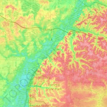
Name: Topografische Karte Torreya State Park, Höhe, Relief.
Ort: Torreya State Park, Liberty County, Florida, United States (30.48402 -84.97138 30.69425 -84.86137)
Durchschnittliche Höhe: 47 m
Minimale Höhe: 6 m
Maximale Höhe: 94 m
Andere topografische Karten
Klicken Sie auf eine Karte, um ihre Topografie, ihre Höhe und ihr Relief anzuzeigen.