
Topografische Karte Mount Bachelor
Interaktive Karte
Klicken Sie auf die Karte, um die Höhe anzuzeigen.
Über diese Karte
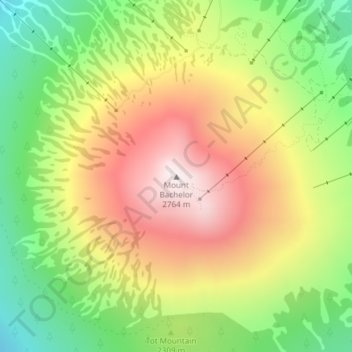
Name: Topografische Karte Mount Bachelor, Höhe, Relief.
Ort: Mount Bachelor, Deschutes County, Oregon, United States (43.97923 -121.68842 43.97933 -121.68832)
Durchschnittliche Höhe: 2.327 m
Minimale Höhe: 1.928 m
Maximale Höhe: 2.756 m
Mount Bachelor lies in the Cascade Range, within Deschutes County, in the U.S. state of Oregon. It is located south of the Three Sisters complex volcano, and reaches an elevation of 9,068 feet (2,764 m). It rises 3,500 feet (1,100 m) above its base, with a proximal relief of 2,674 feet (815 m). The volcano has a volume of 6.0 cubic miles (25 km3). Mount Bachelor stands 3 miles (4.8 km) southeast of the Tumalo Mountain volcano and 18 miles (29 km) to the southwest of the city of Bend, in the Deschutes National Forest.
Andere topografische Karten
Klicken Sie auf eine Karte, um ihre Topografie, ihre Höhe und ihr Relief anzuzeigen.
Bend
United States > Oregon > Deschutes County
Bend, Deschutes County, Oregon, United States
Durchschnittliche Höhe: 1.121 m
Badlands Rock
United States > Oregon > Deschutes County
Badlands Rock, Deschutes County, Oregon, United States
Durchschnittliche Höhe: 1.090 m
Sunriver
United States > Oregon > Deschutes County
Sunriver, Deschutes County, Oregon, 97707, United States
Durchschnittliche Höhe: 1.312 m
Redmond
United States > Oregon > Deschutes County
Redmond, Deschutes County, Oregon, 91156, United States
Durchschnittliche Höhe: 923 m
La Pine
United States > Oregon > Deschutes County
La Pine, Deschutes County, Oregon, 97739, United States
Durchschnittliche Höhe: 1.290 m
Anns Butte
United States > Oregon > Deschutes County
Anns Butte, Deschutes County, Oregon, United States
Durchschnittliche Höhe: 1.312 m
Sisters
United States > Oregon > Deschutes County
Sisters, Deschutes County, Oregon, United States
Durchschnittliche Höhe: 973 m
Archie Briggs Canyon Natural Area
United States > Oregon > Deschutes County > Bend
Archie Briggs Canyon Natural Area, Northwest Falcon Ridge, Bend, Deschutes County, Oregon, 97703, United States
Durchschnittliche Höhe: 1.115 m
Three Rivers
United States > Oregon > Deschutes County > Sunriver
Three Rivers, Sunriver, Deschutes County, Oregon, United States
Durchschnittliche Höhe: 1.296 m
Three Sisters
United States > Oregon > Deschutes County
Three Sisters, Deschutes County, Oregon, United States
Durchschnittliche Höhe: 2.526 m
Lava Butte
United States > Oregon > Deschutes County
Lava Butte, Deschutes County, Oregon, United States
Durchschnittliche Höhe: 1.365 m
Smith Rock State Park
United States > Oregon > Deschutes County > Terrebonne
Smith Rock State Park, 9241, Northeast Crooked River Drive, Terrebonne, Deschutes County, Oregon, 97760, United States
Durchschnittliche Höhe: 875 m
Terrebonne
United States > Oregon > Deschutes County > Terrebonne
Terrebonne, Deschutes County, Oregon, United States
Durchschnittliche Höhe: 855 m
Tumalo Falls
United States > Oregon > Deschutes County
Tumalo Falls, Deschutes County, Oregon, United States
Durchschnittliche Höhe: 1.656 m
Deschutes River Woods
United States > Oregon > Deschutes County
Deschutes River Woods, Deschutes County, Oregon, United States
Durchschnittliche Höhe: 1.210 m
Vista Butte
United States > Oregon > Deschutes County
Vista Butte, Deschutes County, Oregon, United States
Durchschnittliche Höhe: 1.864 m
Crane Prairie Reservoir
United States > Oregon > Deschutes County
Crane Prairie Reservoir, Deschutes County, Oregon, United States
Durchschnittliche Höhe: 1.375 m
Brothers
United States > Oregon > Deschutes County
Brothers, Deschutes County, Oregon, United States
Durchschnittliche Höhe: 1.410 m
Pilot Butte
United States > Oregon > Deschutes County > Bend
Pilot Butte, Bend, Deschutes County, Oregon, 97701, United States
Durchschnittliche Höhe: 1.113 m