
Spenden
Topografische Karte Montrock
Klicken Sie auf die Karte, um die Höhe anzuzeigen.
Spenden
Über diese Karte
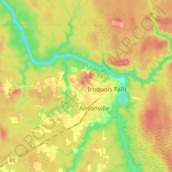
Name: Topografische Karte Montrock, Höhe, Relief.
Durchschnittliche Höhe: 273 m
Minimale Höhe: 233 m
Maximale Höhe: 309 m
Spenden
Andere topografische Karten
Klicken Sie auf eine Karte, um ihre Topografie, ihre Höhe und ihr Relief anzuzeigen.
Wadsworth Lake
Canada > Ontario > Cochrane District > Unorganized North Cochrane
Durchschnittliche Höhe: 323 m
Cochrane
Canada > Ontario > Cochrane District
Until 1977, Timmins was used as the source for all weather readings attributed to Cochrane except for exceptional extremes, due to the overall similar climate due to proximity and topography. However, in December 1977, Cochrane temperature readings began to be taken from downtown after a noticeable difference…
Durchschnittliche Höhe: 262 m
Spenden
Jack Lake
Canada > Ontario > Cochrane District > Unorganized North Cochrane
Durchschnittliche Höhe: 274 m
Painkiller Lake
Canada > Ontario > Cochrane District > Black River-Matheson Township
Durchschnittliche Höhe: 302 m
Borgford Lake
Canada > Ontario > Cochrane District > Black River-Matheson Township
Durchschnittliche Höhe: 346 m
Kapuskasing
Canada > Ontario > Cochrane District
Kapuskasing lies in the heart of the Great Clay Belt. The topography of the region is very flat, dotted with numerous small lakes and muskeg bogs. Also in the heart of Canada's boreal forest, the region is drained by rivers running north to James Bay. The district is heavily forested, mostly by thick stands of…
Durchschnittliche Höhe: 227 m
Spenden
Arrow Lake
Canada > Ontario > Cochrane District > Unorganized South West Cochrane
Durchschnittliche Höhe: 297 m
Spenden
Beatty
Canada > Ontario > Cochrane District > Black River-Matheson Township
Durchschnittliche Höhe: 295 m
Watersnake Lake
Canada > Ontario > Cochrane District > Fauquier-Strickland Township
Durchschnittliche Höhe: 233 m
Spenden
Snare Lake
Canada > Ontario > Cochrane District > Unorganized North Cochrane
Durchschnittliche Höhe: 300 m
Ptarmigan Lake
Canada > Ontario > Cochrane District > Unorganized North Cochrane
Durchschnittliche Höhe: 225 m
Spenden
Frederick House Lake
Canada > Ontario > Cochrane District > Iroquois Falls
Durchschnittliche Höhe: 286 m
Lady Lake
Canada > Ontario > Cochrane District > Unorganized North Cochrane
Durchschnittliche Höhe: 310 m
Spenden
Joseph Lake
Canada > Ontario > Cochrane District > Unorganized North Cochrane
Durchschnittliche Höhe: 271 m
Moose Factory Island
Canada > Ontario > Cochrane District > Unorganized North Cochrane
Durchschnittliche Höhe: 4 m
Bobs Lake
Canada > Ontario > Cochrane District > Unorganized North Cochrane
Durchschnittliche Höhe: 291 m
Spenden
Ghost River
Canada > Ontario > Cochrane District > Unorganized North Cochrane
Durchschnittliche Höhe: 287 m
Spenden
Kabinakagami River
Canada > Ontario > Cochrane District > Unorganized North Cochrane
Durchschnittliche Höhe: 250 m
Spenden
Teal Creek
Canada > Ontario > Cochrane District > Unorganized North Cochrane
Durchschnittliche Höhe: 203 m
Ghost Lake;Pearce Creek
Canada > Ontario > Cochrane District > Unorganized North Cochrane
Durchschnittliche Höhe: 213 m
Unorganized South West Cochrane
Canada > Ontario > Cochrane District > Unorganized South West Cochrane
Durchschnittliche Höhe: 312 m
Watabeag River
Canada > Ontario > Cochrane District > Black River-Matheson Township
Durchschnittliche Höhe: 261 m
Spenden
Sheen Lake
Canada > Ontario > Cochrane District > Unorganized North Cochrane
Durchschnittliche Höhe: 282 m
Moose Factory Island
Canada > Ontario > Cochrane District > Unorganized North Cochrane
Durchschnittliche Höhe: 4 m
Kapuskasing
Canada > Ontario > Cochrane District
Kapuskasing lies in the heart of the Great Clay Belt. The topography of the region is very flat, dotted with numerous small lakes and muskeg bogs. Also in the heart of Canada's boreal forest, the region is drained by rivers running north to James Bay. The district is heavily forested, mostly by thick stands of…
Durchschnittliche Höhe: 227 m
Spenden
Big Cedar Creek
Canada > Ontario > Cochrane District > Unorganized North Cochrane
Durchschnittliche Höhe: 49 m
Beatty
Canada > Ontario > Cochrane District > Black River-Matheson Township
Durchschnittliche Höhe: 295 m
Spenden
Spenden
Spenden