
Topografische Karte Qumarlêb County
Interaktive Karte
Klicken Sie auf die Karte, um die Höhe anzuzeigen.
Über diese Karte
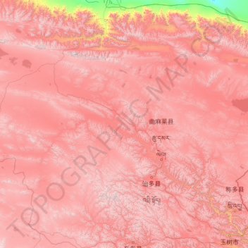
Name: Topografische Karte Qumarlêb County, Höhe, Relief.
Durchschnittliche Höhe: 4.505 m
Minimale Höhe: 2.718 m
Maximale Höhe: 5.916 m
With an elevation of around 4,200 metres (14,000 ft), Qumarlêb County has an alpine climate (Köppen ETH), with long, very cold winters, and short, cool and rainy summers. Average low temperatures are below freezing from mid September to late May; however, due to the wide diurnal temperature variation, average highs are only below freezing from mid/late November until early March. Despite frequent rain during summer, when a majority of days sees rain, no month has less than 50 percent of possible sunshine; with monthly percent possible sunshine ranging from 51 percent in June to 78 percent in November, the county seat receives 2,782 hours of bright sunshine annually. The monthly 24-hour average temperature ranges from −14.5 °C (5.9 °F) in January to 8.9 °C (48.0 °F) in July, while the annual mean is −2.13 °C (28.2 °F). Over three-fourths of the annual precipitation of 406 mm (16.0 in) is delivered from June to September.
Andere topografische Karten
Klicken Sie auf eine Karte, um ihre Topografie, ihre Höhe und ihr Relief anzuzeigen.
Haixi Mongol and Tibetan Autonomous Prefecture
Haixi Mongol and Tibetan Autonomous Prefecture, Qinghai, China
Durchschnittliche Höhe: 3.739 m
Ulan County
Ulan County, Haixi Mongol and Tibetan Autonomous Prefecture, Qinghai, 817100, China
Durchschnittliche Höhe: 3.593 m
Yanshiping
China > Qinghai > Yanshiping
Yanshiping, Golmud City, Haixi Mongol and Tibetan Autonomous Prefecture, Qinghai, China
Durchschnittliche Höhe: 4.958 m