
Topografische Karte Onalaska
Interaktive Karte
Klicken Sie auf die Karte, um die Höhe anzuzeigen.
Über diese Karte
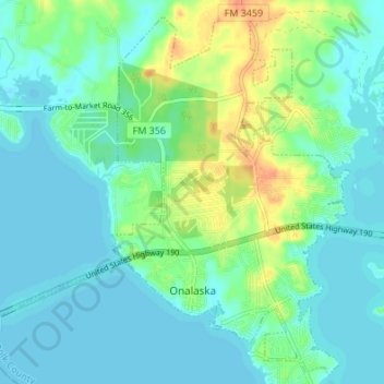
Name: Topografische Karte Onalaska, Höhe, Relief.
Ort: Onalaska, Polk County, Texas, 77360, United States (30.79285 -95.15635 30.84829 -95.08862)
Durchschnittliche Höhe: 49 m
Minimale Höhe: 39 m
Maximale Höhe: 77 m
Andere topografische Karten
Klicken Sie auf eine Karte, um ihre Topografie, ihre Höhe und ihr Relief anzuzeigen.
Livingston
United States > Texas > Polk County
Livingston, Polk County, Texas, United States
Durchschnittliche Höhe: 63 m
Lake Livingston
United States > Texas > Polk County
Lake Livingston, Polk County, Texas, United States
Durchschnittliche Höhe: 66 m
Lake Livingston State Park
United States > Texas > Polk County
Lake Livingston State Park, Polk County, Texas, United States
Durchschnittliche Höhe: 43 m
Segno
United States > Texas > Polk County
Segno, Polk County, Texas, United States
Durchschnittliche Höhe: 60 m
West Livingston
United States > Texas > Polk County
West Livingston, Polk County, Texas, 77351, United States
Durchschnittliche Höhe: 42 m
Corrigan
United States > Texas > Polk County
Corrigan, Polk County, Texas, 75939, United States
Durchschnittliche Höhe: 76 m
Tobacco Patch
United States > Texas > Polk County > Tobacco Patch
Tobacco Patch, Polk County, Texas, United States
Durchschnittliche Höhe: 43 m
Asia
United States > Texas > Polk County > Asia
Asia, Polk County, Texas, 75939, United States
Durchschnittliche Höhe: 80 m
Dallardsville
United States > Texas > Polk County > Dallardsville
Dallardsville, Polk County, Texas, 77332, United States
Durchschnittliche Höhe: 76 m
Goodrich
United States > Texas > Polk County
Goodrich, Polk County, Texas, United States
Durchschnittliche Höhe: 38 m
Seven Oaks
United States > Texas > Polk County
Seven Oaks, Polk County, Texas, United States
Durchschnittliche Höhe: 68 m
Blanchard
United States > Texas > Polk County
Blanchard, Polk County, Texas, United States
Durchschnittliche Höhe: 47 m