
Spenden
Topografische Karte Dr. B. R. Ambedkar Konaseema
Klicken Sie auf die Karte, um die Höhe anzuzeigen.
Spenden
Über diese Karte
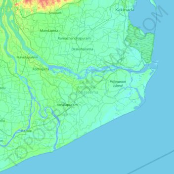
Name: Topografische Karte Dr. B. R. Ambedkar Konaseema, Höhe, Relief.
Ort: Dr. B. R. Ambedkar Konaseema, Andhra Pradesh, India (16.31028 81.70079 16.98021 82.36173)
Durchschnittliche Höhe: 5 m
Minimale Höhe: -4 m
Maximale Höhe: 64 m
Spenden
Andere topografische Karten
Klicken Sie auf eine Karte, um ihre Topografie, ihre Höhe und ihr Relief anzuzeigen.
Spenden
Hindupur
India > Andhra Pradesh > Hindupur
Even in summers, the city experiences lower temperatures compared to the rest of the state due to its high elevation. Every Year, The lowest temperature will be around 3 degrees and highest temperature will be around 11 degrees. Average annual rainfall is 551mm.
Durchschnittliche Höhe: 623 m
Spenden
Spenden
Spenden
Spenden
Spenden
Spenden
Spenden
Savalavandlapalle
India > Andhra Pradesh > Rompicherla > Balondgireddigaripalle
Durchschnittliche Höhe: 543 m
Spenden
Spenden
Spenden
Kakinada
India > Andhra Pradesh > Kakinada (Urban)
Kakinada is located at 16°56′N 82°13′E / 16.93°N 82.22°E / 16.93; 82.22, with the 82-degrees east longitude passing through the city. The city has an average elevation of 2 meters (6.6 feet), and several areas lie below sea level.
Durchschnittliche Höhe: 7 m
Kurnool
India > Andhra Pradesh > Kurnool
Kurnool is located at 15°50′00″N 78°03′00″E / 15.8333°N 78.05°E / 15.8333; 78.05. It has an average elevation of 273 metres (898 feet). Kurnool lies on the banks of the Tungabhadra River. The Hundri and Neeva rivers also flow through the city. The K.C.Canal (Kurnool–Cuddapah) was built…
Durchschnittliche Höhe: 307 m
Visakhapatnam
India > Andhra Pradesh > Visakhapatnam (Urban)
The city is situated between the Eastern Ghats and the Bay of Bengal. The city coordinates lies between 17.7041 N and 83.2977 E. The city's area is 682 km2. The average elevation is 45 metres. Visakhpatnam is situated in Coastal Andhra Region.
Durchschnittliche Höhe: 35 m
Kadapa
India > Andhra Pradesh > Kadapa
Kadapa in the Rayalaseema region of Andhra Pradesh is located at 14°28′N 78°49′E / 14.47°N 78.82°E / 14.47; 78.82 about 412 km from Hyderabad, 260 km from Chennai, 250 km from Bangalore and 360 km from Vijayawada. The city is situated in the Bugga vanka or Ralla Vanka rivers bordered by the…
Durchschnittliche Höhe: 257 m
Spenden
Madanapalle
India > Andhra Pradesh > Madanapalle
It is located at an average elevation of 695 m (2,280 ft) above mean sea level.
Durchschnittliche Höhe: 765 m
Rajamahendravaram
India > Andhra Pradesh > Rajahmundry (Urban)
Rajahmundry is located at 16°59′N 81°47′E / 16.98°N 81.78°E / 16.98; 81.78. with an average elevation of 14 metres (46 ft). It is geographically located at centre of Godavari Districts.There is paddy, sugarcane and various varieties of flowers cultivation in the area. River Godavari flows…
Durchschnittliche Höhe: 29 m
Spenden
Vijayawada
India > Andhra Pradesh > Vijayawada (Urban)
Vijayawada lies on the banks of Krishna river, covered by hills and canals. and at an altitude of 11 m (36 ft) above sea level. Three canals originating from the north side of the Prakasam Barrage reservoir — Eluru, Bandar, and Ryves — flow through the city.
Durchschnittliche Höhe: 37 m
Spenden
Bhavani Island
India > Andhra Pradesh > Thullur > Amaravati > Venkatapalem
Durchschnittliche Höhe: 19 m
Spenden
Poojarivaripalli
India > Andhra Pradesh > Kurabalakota > Eguvakurivaripalle
Durchschnittliche Höhe: 736 m
Spenden
Spenden
Spenden
Rapur
India > Andhra Pradesh > Rapur
Rapur is located at 14.2000°N 79.5167°E. It has an average elevation of 90 meters (298 feet). Rapur comes under Nellore district and has a border with Kadapa district. Rapur town is surrounded by very big hills named veligonda which makes it a sightseeing place especially in winter and rainy seasons.…
Durchschnittliche Höhe: 91 m
Spenden
Spenden
Spenden
Banakacharla to VBR Link Canal
India > Andhra Pradesh > Jupadu Bungalow > Pothulapadu
Durchschnittliche Höhe: 266 m
Spenden
Guntur
India > Andhra Pradesh > Guntur
Guntur is located at 16°17′N 80°26′E / 16.29°N 80.43°E / 16.29; 80.43. It has an average elevation of 33 metres (108 ft) and is situated on the plains. There are few hills in the surrounding suburban areas and Perecherla Reserve Forest is located in the city's north-west. Guntur lies…
Durchschnittliche Höhe: 29 m
Spenden
Ongole
India > Andhra Pradesh > Ongole
Ongole is located at 15.5°N 80.05°E. It has an average elevation of 10 m (33 ft) AMSL and is situated on plains. The city is around 149 kilometres (93 mi) to the southwest of Amaravati, the state capital.
Durchschnittliche Höhe: 15 m
Spenden
Spenden