
Topografische Karte McGregor
Interaktive Karte
Klicken Sie auf die Karte, um die Höhe anzuzeigen.
Über diese Karte
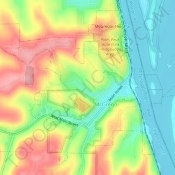
Name: Topografische Karte McGregor, Höhe, Relief.
Ort: McGregor, Clayton County, Iowa, United States (43.01239 -91.20072 43.03634 -91.16818)
Durchschnittliche Höhe: 251 m
Minimale Höhe: 185 m
Maximale Höhe: 333 m
Andere topografische Karten
Klicken Sie auf eine Karte, um ihre Topografie, ihre Höhe und ihr Relief anzuzeigen.
Garber
United States > Iowa > Clayton County
Garber, Clayton County, Iowa, United States
Durchschnittliche Höhe: 231 m
Strawberry Point
United States > Iowa > Clayton County
Strawberry Point, Clayton County, Iowa, United States
Durchschnittliche Höhe: 354 m
Volga
United States > Iowa > Clayton County
Volga, Clayton County, Iowa, United States
Durchschnittliche Höhe: 255 m
Marquette
United States > Iowa > Clayton County
Marquette, Clayton County, Iowa, 52158, United States
Durchschnittliche Höhe: 231 m
Garnavillo
United States > Iowa > Clayton County
Garnavillo, Clayton County, Iowa, United States
Durchschnittliche Höhe: 315 m
Guttenberg
United States > Iowa > Clayton County
Guttenberg, Clayton County, Iowa, United States
Durchschnittliche Höhe: 218 m
Luana
United States > Iowa > Clayton County
Luana, Clayton County, Iowa, 52156, United States
Durchschnittliche Höhe: 335 m
North Buena Vista
United States > Iowa > Clayton County
North Buena Vista, Clayton County, Iowa, 52066, United States
Durchschnittliche Höhe: 235 m
Osterdock
United States > Iowa > Clayton County
Osterdock, Clayton County, Iowa, United States
Durchschnittliche Höhe: 227 m
Clayton
United States > Iowa > Clayton County
Clayton, Clayton County, Iowa, United States
Durchschnittliche Höhe: 243 m
Farmersburg
United States > Iowa > Clayton County
Farmersburg, Clayton County, Iowa, United States
Durchschnittliche Höhe: 297 m
Elkport
United States > Iowa > Clayton County
Elkport, Clayton County, Iowa, United States
Durchschnittliche Höhe: 226 m
Elkader
United States > Iowa > Clayton County
Elkader, Clayton County, Iowa, United States
Durchschnittliche Höhe: 252 m
Pikes Peak State Park
United States > Iowa > Clayton County > McGregor
Pikes Peak State Park, McGregor, Clayton County, Iowa, United States
Durchschnittliche Höhe: 250 m
West Yards
United States > Iowa > Clayton County > Marquette > West Yards
West Yards, Marquette, Clayton County, Iowa, 52158, United States
Durchschnittliche Höhe: 264 m
Edgewood
United States > Iowa > Clayton County
Edgewood, Clayton County, Iowa, United States
Durchschnittliche Höhe: 352 m
St. Olaf
United States > Iowa > Clayton County
St. Olaf, Clayton County, Iowa, United States
Durchschnittliche Höhe: 282 m