
Topografische Karte Fontainemore
Interaktive Karte
Klicken Sie auf die Karte, um die Höhe anzuzeigen.
Über diese Karte
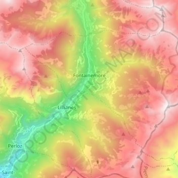
Name: Topografische Karte Fontainemore, Höhe, Relief.
Ort: Fontainemore, Aosta Valley, Italy (45.61253 7.81542 45.67068 7.93950)
Durchschnittliche Höhe: 1.578 m
Minimale Höhe: 346 m
Maximale Höhe: 2.576 m
Andere topografische Karten
Klicken Sie auf eine Karte, um ihre Topografie, ihre Höhe und ihr Relief anzuzeigen.
Aosta
Italy > Aosta Valley > Aosta
Aosta, Aosta / Aoste, Aosta Valley, 11100, Italy
Durchschnittliche Höhe: 1.992 m
Rhêmes-Saint-Georges
Italy > Aosta Valley > Rhêmes-Saint-Georges
Rhêmes-Saint-Georges, Aosta Valley, Italy
Durchschnittliche Höhe: 2.109 m
Valsavarenche
Italy > Aosta Valley > Valsavarenche
Valsavarenche, Aosta Valley, 11010, Italy
Durchschnittliche Höhe: 2.543 m
Dent d'Hérens
Italy > Aosta Valley > Bionaz
Dent d'Hérens, Bionaz, Aosta Valley, Italy
Durchschnittliche Höhe: 3.354 m
Gran Paradiso
Italy > Aosta Valley > Valsavarenche
Gran Paradiso, Valsavarenche, Aosta Valley, Italy
Durchschnittliche Höhe: 3.459 m