
Spenden
Topografische Karte Newcastle upon Tyne
Klicken Sie auf die Karte, um die Höhe anzuzeigen.
Spenden
Über diese Karte
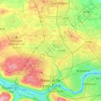
Name: Topografische Karte Newcastle upon Tyne, Höhe, Relief.
Durchschnittliche Höhe: 57 m
Minimale Höhe: -4 m
Maximale Höhe: 140 m
Spenden
Andere topografische Karten
Klicken Sie auf eine Karte, um ihre Topografie, ihre Höhe und ihr Relief anzuzeigen.
Old Sunniside
United Kingdom > England > Tyne and Wear > Gateshead > Sunniside
Durchschnittliche Höhe: 147 m
South Shields
United Kingdom > England > Tyne and Wear > South Tyneside
The current town was founded in 1245 and developed as a fishing port. The name South Shields developed from the 'Schele' or 'Shield', which was a small dwelling used by fishermen. Another industry that was introduced, was that of salt-panning, later expanded upon in the 15th century, polluting the air and…
Durchschnittliche Höhe: 23 m
Spenden
Heaton Park
United Kingdom > England > Tyne and Wear > Newcastle upon Tyne
Durchschnittliche Höhe: 44 m
Low Eighton
United Kingdom > England > Tyne and Wear > Birtley > Lamesley
Durchschnittliche Höhe: 75 m
Spenden
Spenden
Leazes Park
United Kingdom > England > Tyne and Wear > Newcastle upon Tyne
Durchschnittliche Höhe: 71 m
Spenden
Gateshead
United Kingdom > England > Tyne and Wear > Gateshead > Gateshead
One of the most distinguishing features of Gateshead is its topography. The land rises 230 feet from Gateshead Quays to the town centre and continues rising to a height of 525 feet at Queen Elizabeth Hospital in Sheriff Hill. This is in contrast to the flat and low lying Team Valley located on the western…
Durchschnittliche Höhe: 62 m
West Herrington
United Kingdom > England > Tyne and Wear > Sunderland > New Herrington
Durchschnittliche Höhe: 88 m
Jesmond Dene
United Kingdom > England > Tyne and Wear > Newcastle upon Tyne
Durchschnittliche Höhe: 56 m
Spenden
Silverhill Wood
United Kingdom > England > Tyne and Wear > Gateshead > Lamesley
Durchschnittliche Höhe: 123 m
Spenden
Spenden
Marley Hill
United Kingdom > England > Tyne and Wear > Gateshead > Sunniside
Durchschnittliche Höhe: 157 m
Sedgeletch
United Kingdom > England > Tyne and Wear > Sunderland > High Dubmire
Durchschnittliche Höhe: 54 m
Spenden
Spenden
Hunters Moor
United Kingdom > England > Tyne and Wear > Newcastle upon Tyne
Durchschnittliche Höhe: 89 m
Quarry Park
United Kingdom > England > Tyne and Wear > Newcastle upon Tyne
Durchschnittliche Höhe: 60 m
Spenden
Street Gate
United Kingdom > England > Tyne and Wear > Gateshead > Street Gate
Durchschnittliche Höhe: 132 m
Smith's Dock
United Kingdom > England > Tyne and Wear > North Tyneside > North Shields
Durchschnittliche Höhe: 21 m
Winlaton Mill Millennium Green
United Kingdom > England > Tyne and Wear > Gateshead > Winlaton Mill
Durchschnittliche Höhe: 75 m
Spenden
Spenden
South Shields
United Kingdom > England > Tyne and Wear > South Tyneside
The current town was founded in 1245 and developed as a fishing port. The name South Shields developed from the 'Schele' or 'Shield', which was a small dwelling used by fishermen. Another industry that was introduced, was that of salt-panning, later expanded upon in the 15th century, polluting the air and…
Durchschnittliche Höhe: 23 m
Spenden
Stella Wood
United Kingdom > England > Tyne and Wear > Gateshead > Stella
Durchschnittliche Höhe: 49 m
Spenden
South Shields
United Kingdom > England > Tyne and Wear > South Tyneside
The current town was founded in 1245 and developed as a fishing port. The name South Shields developed from the 'Schele' or 'Shield', which was a small dwelling used by fishermen. Another industry that was introduced was that of salt-panning, later expanded upon in the 15th century, polluting the air and…
Durchschnittliche Höhe: 23 m