
Topografische Karte Moeraki
Interaktive Karte
Klicken Sie auf die Karte, um die Höhe anzuzeigen.
Über diese Karte
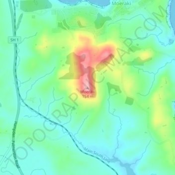
Name: Topografische Karte Moeraki, Höhe, Relief.
Ort: Moeraki, Waitaki District, Otago, 9482, New Zealand (-45.37405 170.84409 -45.37395 170.84419)
Durchschnittliche Höhe: 42 m
Minimale Höhe: 0 m
Maximale Höhe: 152 m
Andere topografische Karten
Klicken Sie auf eine Karte, um ihre Topografie, ihre Höhe und ihr Relief anzuzeigen.
Oamaru
New Zealand > Otago > Waitaki District
Oamaru, Waitaki District, Otago, 9444, New Zealand
Durchschnittliche Höhe: 34 m
Tokarahi
New Zealand > Otago > Waitaki District
Tokarahi, Waitaki District, Otago, New Zealand
Durchschnittliche Höhe: 274 m
Pukeuri
New Zealand > Otago > Waitaki District
Pukeuri, Waitaki District, Otago, New Zealand
Durchschnittliche Höhe: 44 m
Moonlight
New Zealand > Otago > Waitaki District
Moonlight, Waitaki District, Otago, New Zealand
Durchschnittliche Höhe: 478 m
Waitaki Bridge
New Zealand > Otago > Waitaki District
Waitaki Bridge, Waitaki District, Otago, 7980, New Zealand
Durchschnittliche Höhe: 19 m
Macraes
New Zealand > Otago > Waitaki District > Macraes
Macraes, Waitaki District, Otago, New Zealand
Durchschnittliche Höhe: 503 m
Taranui
New Zealand > Otago > Waitaki District > Kakanui > Taranui
Taranui, Kakanui, Waitaki District, Otago, New Zealand
Durchschnittliche Höhe: 15 m
Waynes
New Zealand > Otago > Waitaki District > Waynes
Waynes, Waitaki District, Otago, New Zealand
Durchschnittliche Höhe: 121 m