Geolokalisieren
👉 Easily get elevation data in JSON, GeoTIFF and KML formats using Elevation API
Vielen Dank für die Unterstützung dieser Website ❤️
Spenden

Topografische Karte Norrisville

Klicken Sie auf die Karte, um die Höhe anzuzeigen.

👉 Easily get elevation data in JSON, GeoTIFF and KML formats using Elevation API
Vielen Dank für die Unterstützung dieser Website ❤️
Spenden

Über diese Karte

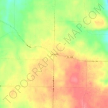
Name: Topografische Karte Norrisville, Höhe, Relief.

Ort: Norrisville, Hayfield Township, Crawford County, Pennsylvania, United States (41.69589 -80.29006 41.73589 -80.25006)

Durchschnittliche Höhe: 415 m

Minimale Höhe: 369 m

Maximale Höhe: 445 m

👉 Easily get elevation data in JSON, GeoTIFF and KML formats using Elevation API
Vielen Dank für die Unterstützung dieser Website ❤️
Spenden

Andere topografische Karten

Klicken Sie auf eine Karte, um ihre Topografie, ihre Höhe und ihr Relief anzuzeigen.

Centerville

United States > Pennsylvania > Crawford County

Centerville Borough is located just north of the southern terminal moraine for glaciation in northwestern Pennsylvania. The borough is drained by Oil Creek, a southward-flowing tributary of the Allegheny River, which runs through the western side of town and East Branch Oil Creek, which enters the borough from…

Durchschnittliche Höhe: 409 m

Lincolnville

United States > Pennsylvania > Crawford County

Durchschnittliche Höhe: 435 m

Hartstown

United States > Pennsylvania > Crawford County

Durchschnittliche Höhe: 328 m

Blooming Valley

United States > Pennsylvania > Crawford County

The Borough of Blooming Valley lies on the divide between Blooming Valley Run and Sugar Creek, whose waters eventually flow to French Creek. The two streams are separated by a swampy area. The elevation of the borough ranges from 1,219 ft (372 m) at Blooming Valley Run to 1,530 ft (470 m) near the eastern…

Durchschnittliche Höhe: 403 m

Vielen Dank für die Unterstützung dieser Website ❤️
Spenden

Guys Mills

United States > Pennsylvania > Crawford County

Durchschnittliche Höhe: 429 m

Pymatuning Central

United States > Pennsylvania > Crawford County

Durchschnittliche Höhe: 332 m

Cochranton

United States > Pennsylvania > Crawford County

Durchschnittliche Höhe: 351 m

Vielen Dank für die Unterstützung dieser Website ❤️
Spenden

Conneautville

United States > Pennsylvania > Crawford County

Durchschnittliche Höhe: 308 m

Hydetown

United States > Pennsylvania > Crawford County

Hydetown Borough is located just south of the southern terminal moraine for glaciation in northwestern Pennsylvania. The borough is drained by Oil Creek, a southward-flowing tributary of the Allegheny River, which runs through the northwestern and southwestern sides of the borough and Thompson Creek, which…

Durchschnittliche Höhe: 412 m

Linesville

United States > Pennsylvania > Crawford County

Durchschnittliche Höhe: 325 m

Springboro

United States > Pennsylvania > Crawford County

Durchschnittliche Höhe: 306 m

Vielen Dank für die Unterstützung dieser Website ❤️
Spenden

Venango

United States > Pennsylvania > Crawford County

Durchschnittliche Höhe: 365 m

Adamsville

United States > Pennsylvania > Crawford County

Durchschnittliche Höhe: 337 m

Atlantic

United States > Pennsylvania > Crawford County

Durchschnittliche Höhe: 347 m

Canadohta Lake

United States > Pennsylvania > Crawford County

Durchschnittliche Höhe: 450 m

Vielen Dank für die Unterstützung dieser Website ❤️
Spenden

Harmonsburg

United States > Pennsylvania > Crawford County

Durchschnittliche Höhe: 350 m