
Topografische Karte Suez Canal
Interaktive Karte
Klicken Sie auf die Karte, um die Höhe anzuzeigen.
Über diese Karte
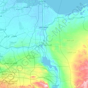
Name: Topografische Karte Suez Canal, Höhe, Relief.
Ort: Suez Canal, Port Said, 43522, Egypt (29.93034 32.30378 31.27571 32.58750)
Durchschnittliche Höhe: 106 m
Minimale Höhe: -6 m
Maximale Höhe: 869 m
Although the alleged difference in sea levels could be problematic for construction, the idea of finding a shorter route to the east remained alive. In 1830, F. R. Chesney submitted a report to the British government that stated that there was no difference in elevation and that the Suez Canal was feasible, but his report received no further attention. Lieutenant Waghorn established his "Overland Route", which transported post and passengers to India via Egypt.
Andere topografische Karten
Klicken Sie auf eine Karte, um ihre Topografie, ihre Höhe und ihr Relief anzuzeigen.
Al-ʿAbbāsiyyah Canal
Al-ʿAbbāsiyyah Canal, Port Said, 41524, Egypt
Durchschnittliche Höhe: 16 m