
Topografische Karte Romblon
Klicken Sie auf die Karte, um die Höhe anzuzeigen.
Über diese Karte
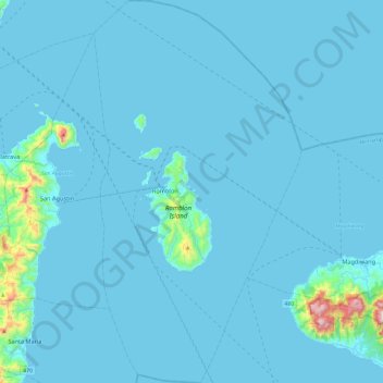
Name: Topografische Karte Romblon, Höhe, Relief.
Ort: Romblon, Mimaropa, 5500, Philippines (12.34309 122.18015 12.80631 122.44099)
Durchschnittliche Höhe: 40 m
Minimale Höhe: -1 m
Maximale Höhe: 829 m
Andere topografische Karten
Klicken Sie auf eine Karte, um ihre Topografie, ihre Höhe und ihr Relief anzuzeigen.
Mount Guiting-Guiting
Philippines > Romblon > Cajidiocan
Mount Guiting-Guiting or G2 is the highest mountain in the province of Romblon, located in Sibuyan Island, in the Philippines, with an elevation of 6,752 ft (2,058 m) above sea level. Its steep slopes and jagged peak, have earned it the reputation, as one of the most difficult and technically most challenging…
Durchschnittliche Höhe: 1.478 m
roadside view of Mt.Guiting-Guiting
Philippines > Romblon > Magdiwang > Sitio Agnonoc
Durchschnittliche Höhe: 10 m