
Topografische Karte Coldwater
Interaktive Karte
Klicken Sie auf die Karte, um die Höhe anzuzeigen.
Über diese Karte
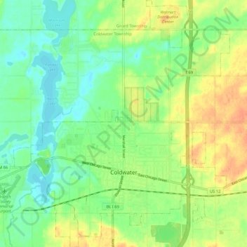
Name: Topografische Karte Coldwater, Höhe, Relief.
Ort: Coldwater, Branch County, Michigan, United States of America (41.91658 -85.04757 41.99473 -84.95543)
Durchschnittliche Höhe: 296 m
Minimale Höhe: 279 m
Maximale Höhe: 318 m
Coldwater is at 41°56′25″N 85°00′02″W / 41.94028°N 85.00056°W / 41.94028; -85.00056. The ZIP code is 49036 and the FIPS place code is 17020. The elevation is 969 feet (295 m) above sea level. The City of Coldwater is entirely surrounded by the Township of Coldwater.