
Spenden
Topografische Karte Willey
Klicken Sie auf die Karte, um die Höhe anzuzeigen.
Spenden
Über diese Karte
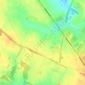
Name: Topografische Karte Willey, Höhe, Relief.
Ort: Willey, Warwickshire, England, United Kingdom (52.44931 -1.29861 52.47201 -1.25293)
Durchschnittliche Höhe: 123 m
Minimale Höhe: 103 m
Maximale Höhe: 136 m
Spenden
Andere topografische Karten
Klicken Sie auf eine Karte, um ihre Topografie, ihre Höhe und ihr Relief anzuzeigen.
Welford on Avon CP
United Kingdom > England > Warwickshire > Stratford-on-Avon
Durchschnittliche Höhe: 44 m
Warwick
United Kingdom > England > Warwickshire
Warwick experiences the usual English maritime climate, marked by a narrow temperature range, mild winters and cool summers. The nearest official Met Office weather station is at Wellesbourne, about 6 miles (10 km) south of the town centre and at a similar elevation. The absolute maximum temperature (also the…
Durchschnittliche Höhe: 87 m
Spenden
Pinley Green
United Kingdom > England > Warwickshire > Warwick > Rowington
Durchschnittliche Höhe: 110 m
Priors Marston
United Kingdom > England > Warwickshire > Stratford-on-Avon
Durchschnittliche Höhe: 151 m
Spenden
Nuneaton
United Kingdom > England > Warwickshire > Nuneaton and Bedworth
Durchschnittliche Höhe: 102 m
Shipston-on-Stour
United Kingdom > England > Warwickshire > Stratford-on-Avon
Durchschnittliche Höhe: 93 m
Spenden
Spenden
Compton Verney CP
United Kingdom > England > Warwickshire > Stratford-on-Avon
Durchschnittliche Höhe: 103 m
Spenden
Newton Regis CP
United Kingdom > England > Warwickshire > North Warwickshire
Durchschnittliche Höhe: 85 m
Water Orton CP
United Kingdom > England > Warwickshire > North Warwickshire
Durchschnittliche Höhe: 84 m
Spenden
Rowington Green
United Kingdom > England > Warwickshire > Warwick > Rowington
Durchschnittliche Höhe: 114 m
Bidford on Avon CP
United Kingdom > England > Warwickshire > Stratford-on-Avon
Durchschnittliche Höhe: 42 m
Brook End
United Kingdom > England > Warwickshire > North Warwickshire > Hurley
Durchschnittliche Höhe: 107 m
Great Wolford
United Kingdom > England > Warwickshire > Stratford-on-Avon
Durchschnittliche Höhe: 111 m
Spenden
Upper Lighthorne
United Kingdom > England > Warwickshire > Stratford-on-Avon
Durchschnittliche Höhe: 115 m
Stratford-on-Avon
United Kingdom > England > Warwickshire > Stratford-on-Avon
Durchschnittliche Höhe: 108 m
Spenden
Birchley Heath
United Kingdom > England > Warwickshire > North Warwickshire
Durchschnittliche Höhe: 151 m
Tanworth in Arden CP
United Kingdom > England > Warwickshire > Stratford-on-Avon
Durchschnittliche Höhe: 139 m
Spenden
Ilmington CP
United Kingdom > England > Warwickshire > Stratford-on-Avon
Durchschnittliche Höhe: 123 m
Stratford-upon-Avon
United Kingdom > England > Warwickshire > Stratford-on-Avon
Durchschnittliche Höhe: 61 m
Spenden
Fillongley CP
United Kingdom > England > Warwickshire > North Warwickshire
Durchschnittliche Höhe: 142 m
Napton on the Hill
United Kingdom > England > Warwickshire > Stratford-on-Avon
Durchschnittliche Höhe: 113 m
Spenden
Fenny Compton CP
United Kingdom > England > Warwickshire > Stratford-on-Avon
Durchschnittliche Höhe: 132 m
Spenden
Spenden
Spenden
Spenden
Hampton on the Hill
United Kingdom > England > Warwickshire > Warwick > Hampton on the Hill
Durchschnittliche Höhe: 75 m
Ansley Common
United Kingdom > England > Warwickshire > North Warwickshire
Durchschnittliche Höhe: 138 m
Bishops Itchington
United Kingdom > England > Warwickshire > Stratford-on-Avon
Durchschnittliche Höhe: 104 m
Spenden
Baddesley Ensor
United Kingdom > England > Warwickshire > North Warwickshire
Durchschnittliche Höhe: 111 m
Spenden
Birmingham and Fazeley Canal
United Kingdom > England > Warwickshire > Minworth
Durchschnittliche Höhe: 105 m
Upper Quinton
United Kingdom > England > Warwickshire > Stratford-on-Avon > Lower Quinton
Durchschnittliche Höhe: 70 m
Lye Green
United Kingdom > England > Warwickshire > Stratford-on-Avon > Claverdon > Lye Green
Durchschnittliche Höhe: 106 m
Spenden
Stretton-on-Fosse
United Kingdom > England > Warwickshire > Stratford-on-Avon
Durchschnittliche Höhe: 108 m
Priors Hardwick CP
United Kingdom > England > Warwickshire > Stratford-on-Avon
Durchschnittliche Höhe: 134 m
Spenden
Cranhill
United Kingdom > England > Warwickshire > Stratford-on-Avon > Ardens Grafton
Durchschnittliche Höhe: 57 m
Spenden
Curdworth Locks
United Kingdom > England > Warwickshire > North Warwickshire > Kingsbury > Curdworth CP
Durchschnittliche Höhe: 80 m
Little Wolford
United Kingdom > England > Warwickshire > Stratford-on-Avon
Durchschnittliche Höhe: 103 m
Spenden
Butlers Marston
United Kingdom > England > Warwickshire > Stratford-on-Avon
Durchschnittliche Höhe: 93 m
Long Itchington
United Kingdom > England > Warwickshire > Stratford-on-Avon
Durchschnittliche Höhe: 80 m
Spenden
Temple Grafton
United Kingdom > England > Warwickshire > Stratford-on-Avon
Durchschnittliche Höhe: 72 m
Chessetts Wood
United Kingdom > England > Warwickshire > Warwick > Lapworth
Durchschnittliche Höhe: 115 m
Spenden
Church End
United Kingdom > England > Warwickshire > North Warwickshire > Ansley CP
Durchschnittliche Höhe: 151 m
Farnborough CP
United Kingdom > England > Warwickshire > Stratford-on-Avon
Durchschnittliche Höhe: 143 m
Haseley Knob
United Kingdom > England > Warwickshire > Warwick > Wroxall
Durchschnittliche Höhe: 117 m
Spenden
Preston Green
United Kingdom > England > Warwickshire > Stratford-on-Avon
Durchschnittliche Höhe: 88 m
Lower Quinton
United Kingdom > England > Warwickshire > Stratford-on-Avon
Durchschnittliche Höhe: 64 m
Edgehill
United Kingdom > England > Warwickshire > Stratford-on-Avon > Radway
Durchschnittliche Höhe: 157 m
Spenden