
Topografische Karte Mount Barker
Interaktive Karte
Klicken Sie auf die Karte, um die Höhe anzuzeigen.
Über diese Karte
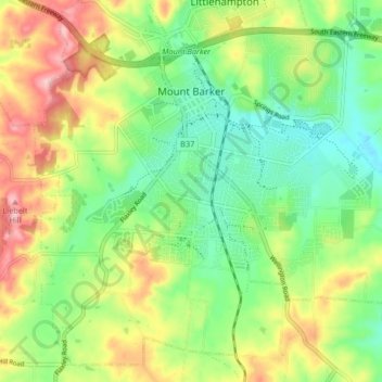
Name: Topografische Karte Mount Barker, Höhe, Relief.
Durchschnittliche Höhe: 368 m
Minimale Höhe: 302 m
Maximale Höhe: 467 m
Mount Barker is located on the plains surrounding the Mount Barker Summit, about 2 km west of the mountain itself, at 35°04′S 138°51′E / 35.067°S 138.850°E / -35.067; 138.850. Mount Barker is south east of Mount Lofty and Adelaide. It is to the north of The Coorong, and the west of Murray Bridge. Mount Barker is at an elevation of 360 m.
Andere topografische Karten
Klicken Sie auf eine Karte, um ihre Topografie, ihre Höhe und ihr Relief anzuzeigen.
Wistow
Australia > South Australia > Mount Barker District Council
Wistow, Mount Barker District Council, South Australia, 5251, Australia
Durchschnittliche Höhe: 334 m
Bull Creek
Australia > South Australia > Mount Barker District Council
Bull Creek, Mount Barker District Council, South Australia, 5157, Australia
Durchschnittliche Höhe: 336 m
Callington
Australia > South Australia > Mount Barker District Council
Callington, Mount Barker District Council, South Australia, 5254, Australia
Durchschnittliche Höhe: 151 m
Prospect Hill
Australia > South Australia > Mount Barker District Council
Prospect Hill, Mount Barker District Council, South Australia, 5201, Australia
Durchschnittliche Höhe: 349 m
Nairne
Australia > South Australia > Mount Barker District Council
Nairne, Mount Barker District Council, South Australia, 5252, Australia
Durchschnittliche Höhe: 383 m
Hahndorf
Australia > South Australia > Mount Barker District Council
Hahndorf, Mount Barker District Council, South Australia, 5245, Australia
Durchschnittliche Höhe: 371 m
Kanmantoo
Australia > South Australia > Mount Barker District Council
Kanmantoo, Mount Barker District Council, South Australia, 5252, Australia
Durchschnittliche Höhe: 198 m