
Topografische Karte Cerro Blanco
Interaktive Karte
Klicken Sie auf die Karte, um die Höhe anzuzeigen.
Über diese Karte
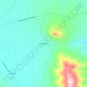
Name: Topografische Karte Cerro Blanco, Höhe, Relief.
Ort: Cerro Blanco, Cardonal, Hidalgo, México (20.58222 -99.08889 20.62222 -99.04889)
Durchschnittliche Höhe: 2.092 m
Minimale Höhe: 1.965 m
Maximale Höhe: 2.540 m
Andere topografische Karten
Klicken Sie auf eine Karte, um ihre Topografie, ihre Höhe und ihr Relief anzuzeigen.
Tolantongo
Tolantongo, Cardonal, Hidalgo, México
Durchschnittliche Höhe: 1.528 m
Las Pocitas "Grutas de Tolantongo"
México > Hidalgo > Cardonal > Tolantongo
Las Pocitas "Grutas de Tolantongo", Tolantongo, Cardonal, Hidalgo, México
Durchschnittliche Höhe: 1.544 m