
Vielen Dank für die Unterstützung dieser Website ❤️
Spenden
Spenden
Topografische Karte Provinz Sofala
Klicken Sie auf die Karte, um die Höhe anzuzeigen.
Vielen Dank für die Unterstützung dieser Website ❤️
Spenden
Spenden
Über diese Karte
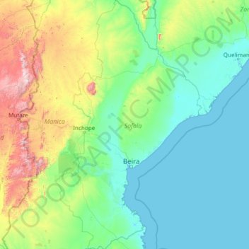
Name: Topografische Karte Provinz Sofala, Höhe, Relief.
Ort: Provinz Sofala, Mosambik (-21.31684 33.38137 -16.80136 36.19341)
Durchschnittliche Höhe: 268 m
Minimale Höhe: -1 m
Maximale Höhe: 2.489 m
Vielen Dank für die Unterstützung dieser Website ❤️
Spenden
Spenden
Andere topografische Karten
Klicken Sie auf eine Karte, um ihre Topografie, ihre Höhe und ihr Relief anzuzeigen.
Maputo
Die Stadt liegt an der Maputo-Bucht am Indischen Ozean und hat nach offiziellen Angaben 1.101.170 Einwohner und in der Agglomeration 2.717.437 (Volkszählung 2017); da viele Menschen in informellen Siedlungen leben und teilweise nicht erfasst sind, gehen Schätzungen von einer weit höheren Einwohnerzahl aus.
Durchschnittliche Höhe: 17 m