
Topografische Karte Pasadena
Interaktive Karte
Klicken Sie auf die Karte, um die Höhe anzuzeigen.
Über diese Karte
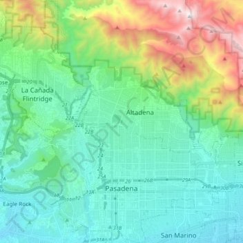
Name: Topografische Karte Pasadena, Höhe, Relief.
Durchschnittliche Höhe: 549 m
Minimale Höhe: 142 m
Maximale Höhe: 1.852 m
An obscure portion of the Angeles Crest Highway (SR 2) in the San Gabriel Mountains cuts through Pasadena near the Angeles Crest Ranger Station. This 2-mile (3.2 km) stretch of highway in the Angeles National Forest is north of La Cañada Flintridge and west of Mount Wilson and is approximately 3,000 feet (910 m) in elevation.