
Spenden
Topografische Karte Ball Creek
Klicken Sie auf die Karte, um die Höhe anzuzeigen.
Spenden
Über diese Karte
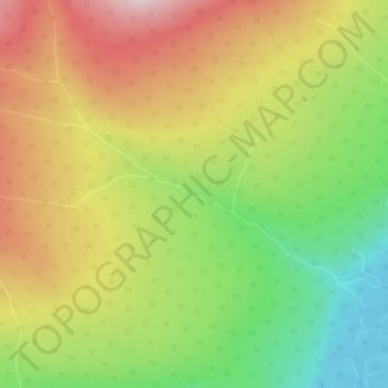
Name: Topografische Karte Ball Creek, Höhe, Relief.
Durchschnittliche Höhe: 1.267 m
Minimale Höhe: 1.043 m
Maximale Höhe: 1.502 m
Spenden
Andere topografische Karten
Klicken Sie auf eine Karte, um ihre Topografie, ihre Höhe und ihr Relief anzuzeigen.
Dease Lake
Canada > British Columbia > Regional District of Kitimat-Stikine > Area F (Dease Lake)
Dease Lake has a subarctic climate (Köppen Dfc), typical of northern British Columbia. Summers are mild, coupled with chilly nights while winters are severely cold and snowy, with annual snowfall averaging 212.8 cm (83.78 in). Autumn typically begins by early September and lasts into October when winter…
Durchschnittliche Höhe: 898 m
Dease Lake
Canada > British Columbia > Regional District of Kitimat-Stikine > Area F (Dease Lake)
Durchschnittliche Höhe: 1.128 m
Mount Dalton
Canada > British Columbia > Regional District of Kitimat-Stikine > Area F (Dease Lake)
Durchschnittliche Höhe: 1.658 m