
Vielen Dank für die Unterstützung dieser Website ❤️
Spenden
Spenden
Topografische Karte El Centinela
Klicken Sie auf die Karte, um die Höhe anzuzeigen.
Vielen Dank für die Unterstützung dieser Website ❤️
Spenden
Spenden
Über diese Karte
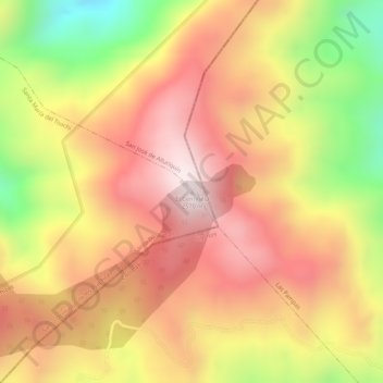
Name: Topografische Karte El Centinela, Höhe, Relief.
Durchschnittliche Höhe: 2.384 m
Minimale Höhe: 2.066 m
Maximale Höhe: 2.577 m
Vielen Dank für die Unterstützung dieser Website ❤️
Spenden
Spenden
Andere topografische Karten
Klicken Sie auf eine Karte, um ihre Topografie, ihre Höhe und ihr Relief anzuzeigen.
Santo Domingo de los Tsachilas
Ecuador > Santo Domingo de los Tsáchilas > Santo Domingo
Santo Domingo is located approximately 133 km west of Quito at an elevation of 625 metres or 2,051 feet. Santo Domingo lies in the foothills west of the Andes. It is important stopping point on the road from Quito to the Pacific coast. The city also connects other lowland cities like Quevedo, Chone, and…
Durchschnittliche Höhe: 695 m