
Spenden
Topografische Karte Penn Park
Klicken Sie auf die Karte, um die Höhe anzuzeigen.
Spenden
Über diese Karte
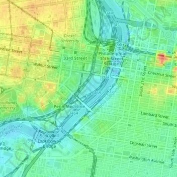
Name: Topografische Karte Penn Park, Höhe, Relief.
Durchschnittliche Höhe: 17 m
Minimale Höhe: -1 m
Maximale Höhe: 45 m
Spenden
Andere topografische Karten
Klicken Sie auf eine Karte, um ihre Topografie, ihre Höhe und ihr Relief anzuzeigen.
South Philadelphia
United States > Pennsylvania > Philadelphia County > Philadelphia
Durchschnittliche Höhe: 6 m
Chestnut Hill
United States > Pennsylvania > Philadelphia County > Philadelphia
The village of Chestnut Hill was part of the German Township laid out by Francis Daniel Pastorius and came to include the settlements originally known as Sommerhausen and Crefeld, as well as part of Cresheim. It served as a gateway between Philadelphia and the nearby farmlands. During the American…
Durchschnittliche Höhe: 97 m
Center City
United States > Pennsylvania > Philadelphia County > Philadelphia
Durchschnittliche Höhe: 14 m
Philadelphia
United States > Pennsylvania > Philadelphia County > Philadelphia
Durchschnittliche Höhe: 35 m
Spenden