
Vielen Dank für die Unterstützung dieser Website ❤️
Spenden
Spenden
Topografische Karte Cintruénigo
Klicken Sie auf die Karte, um die Höhe anzuzeigen.
Vielen Dank für die Unterstützung dieser Website ❤️
Spenden
Spenden
Cintruénigo
The village of Cintruénigo is situated in the autonomous community of Navarre within the Ribera de Navarra at an altitude of 391 MSL. Its area is of 35.4 km2 and limits to the north and northeast with the municipality of Corella, to the east and south with that of Tudela and to the west with that of Fitero.
Vielen Dank für die Unterstützung dieser Website ❤️
Spenden
Spenden
Über diese Karte
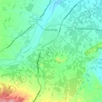
Name: Topografische Karte Cintruénigo, Höhe, Relief.
Ort: Cintruénigo, Erribera / Ribera, 31592, Spain (42.02904 -1.83733 42.10075 -1.74355)
Durchschnittliche Höhe: 427 m
Minimale Höhe: 362 m
Maximale Höhe: 628 m
Vielen Dank für die Unterstützung dieser Website ❤️
Spenden
Spenden