
Topografische Karte Moros
Interaktive Karte
Klicken Sie auf die Karte, um die Höhe anzuzeigen.
Über diese Karte
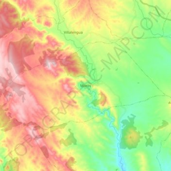
Name: Topografische Karte Moros, Höhe, Relief.
Ort: Moros, Comunidad de Calatayud, Zaragoza, Aragon, Spain (41.36687 -1.91315 41.42871 -1.75219)
Durchschnittliche Höhe: 777 m
Minimale Höhe: 586 m
Maximale Höhe: 1.013 m
Moros is one of the most attractive and picturesque villages of its kind in the area. Its narrow streets zigzag from the square at its highest elevation down to the river bed below. The houses are the main feature of the town. Hundreds of houses have been built tightly against the sunny side of the mountain. They are built with mud and decorated with red and ochre Arabic tiles. Each level of houses rises above the one beneath it to catch the sun as it rises over the valley.
Andere topografische Karten
Klicken Sie auf eine Karte, um ihre Topografie, ihre Höhe und ihr Relief anzuzeigen.
Calatayud
Spain > Aragon > Comunidad de Calatayud
Calatayud, Comunidad de Calatayud, Zaragoza, Aragon, 50300, Spain
Durchschnittliche Höhe: 693 m
Ariza
Spain > Aragon > Comunidad de Calatayud
Ariza, Comunidad de Calatayud, Zaragoza, Aragon, 50220, Spain
Durchschnittliche Höhe: 801 m
Mara
Spain > Aragon > Comunidad de Calatayud
Mara, Comunidad de Calatayud, Zaragoza, Aragon, Spain
Durchschnittliche Höhe: 773 m
Alhama de Aragón
Spain > Aragon > Comunidad de Calatayud > Alhama de Aragón
Alhama de Aragón, Comunidad de Calatayud, Zaragoza, Aragon, Spain
Durchschnittliche Höhe: 763 m