
Spenden
Topografische Karte Nunavik
Klicken Sie auf die Karte, um die Höhe anzuzeigen.
Spenden
Über diese Karte
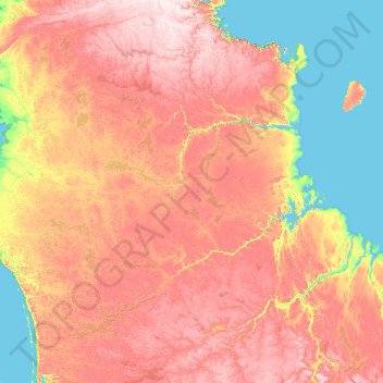
Name: Topografische Karte Nunavik, Höhe, Relief.
Ort: Nunavik, Canada (56.42813 -75.03416 61.62813 -69.83416)
Durchschnittliche Höhe: 191 m
Minimale Höhe: -1 m
Maximale Höhe: 632 m
Spenden
Andere topografische Karten
Klicken Sie auf eine Karte, um ihre Topografie, ihre Höhe und ihr Relief anzuzeigen.
Ontario
Ontario's topography is a diverse tapestry shaped by its vast expanse and geological history. The Canadian Shield dominates the northern and central regions, characterized by ancient Precambrian rock formations, rugged terrain, and numerous lakes and rivers. In contrast, the Hudson Bay Lowlands in the far…
Durchschnittliche Höhe: 245 m
Vancouver
Canada > British Columbia > Metro Vancouver Regional District
Vancouver, British Columbia, is situated on the Burrard Peninsula, bordered by Burrard Inlet to the north and the Fraser River to the south. The city's topography is a blend of flat and hilly terrains, with elevations ranging from sea level to approximately 152 meters (500 feet) above sea level. The North…
Durchschnittliche Höhe: 34 m
British Columbia
British Columbia's topography is a testament to its diverse and dramatic landscapes. Dominated by the Cordillera region, the province features prominent mountain ranges such as the Coast Mountains in the west and the Rocky Mountains in the east. The Coast Mountains, composed of granite rocks from the…
Durchschnittliche Höhe: 708 m
Spenden
Calgary
Calgary, Alberta, is uniquely positioned in the transition zone between the rolling Canadian Prairies to the east and the rugged foothills of the Canadian Rockies to the west, creating a landscape of undulating hills, plateau-like uplands, and deep river valleys. The Bow and Elbow Rivers carve prominent bluffs…
Durchschnittliche Höhe: 1.106 m
Nova Scotia
Nova Scotia's topography is a diverse blend of rugged highlands, rolling hills, and fertile lowlands. The province's landscape is shaped by several upland regions, including the Southern Upland, North Mountain, and Cobequid Mountain, which are interspersed with extensive lowlands. The Southern Upland rises…
Durchschnittliche Höhe: 41 m
Quebec
Quebec's topography is characterized by three main physiographic regions: the Canadian Shield, the St. Lawrence Lowlands, and the Appalachian Mountains. The Canadian Shield, covering about 90% of the province, features rugged terrain with rocky plateaus, rolling hills, and numerous rivers and lakes formed by…
Durchschnittliche Höhe: 195 m
Spenden
Halifax
Canada > Nova Scotia > Halifax County
The coastline is heavily indented, accounting for its length of approximately 400 km (250 mi), with the northern boundary of the municipality usually being between 50–60 km (31–37 mi) inland. The coast is mostly rock with small isolated sand beaches in sheltered bays. The largest coastal features include…
Durchschnittliche Höhe: 46 m
Ottawa
Ottawa, the capital city of Canada, is situated on the south bank of the Ottawa River at the confluence with the Rideau River. The city's topography is characterized by gently rolling terrain with elevations ranging from approximately 44 meters (144 feet) above sea level at the Ottawa River to its highest…
Durchschnittliche Höhe: 105 m
Victoria
Canada > British Columbia > Capital Regional District
Victoria, British Columbia, is situated on the southern tip of Vancouver Island, Canada, and boasts a diverse and varied topography. The city is characterized by rolling hills, rugged coastal cliffs, and lush valleys, providing a striking contrast between mountainous terrain and flatland areas. To the north…
Durchschnittliche Höhe: 17 m
Spenden
Edmonton
Edmonton is on the North Saskatchewan River, at an elevation of 671 m (2,201 ft). It is North America's northernmost city with a metropolitan population over one million. It is at the same latitude as Hamburg (Germany); Dublin (Ireland); Manchester (United Kingdom); and Magnitogorsk (Russia). It is south of…
Durchschnittliche Höhe: 690 m
Newfoundland and Labrador
In 1496, John Cabot obtained a charter from English King Henry VII to "sail to all parts, countries and seas of the East, the West and of the North, under our banner and ensign and to set up our banner on any new-found-land" and on June 24, 1497, landed in Cape Bonavista. Historians disagree on whether Cabot…
Durchschnittliche Höhe: 192 m
Spenden
Kelowna
Canada > British Columbia > Regional District of Central Okanagan
Kelowna is classified as a humid continental climate or an inland oceanic climate per the Köppen climate classification system due to its coldest month having an average temperature slightly above −3.0 °C (26.6 °F) and below 0 °C (32 °F), with dry, hot, sunny summers and cool, cloudy winters, and four…
Durchschnittliche Höhe: 704 m
Winnipeg
Winnipeg lies at the bottom of the Red River Valley, a flood plain with an extremely flat topography. It is on the eastern edge of the Canadian Prairies in Western Canada and is known as the "Gateway to the West". Winnipeg is bordered by tallgrass prairie to the west and south and the aspen parkland to the…
Durchschnittliche Höhe: 236 m
Burnaby
Canada > British Columbia > Metro Vancouver Regional District
Burnaby occupies 98.6 square kilometres (38.1 sq mi) and is located at the geographic centre of the Metro Vancouver Regional District. The regional district's government is located in Burnaby's Metrotown area. Situated between the city of Vancouver on the west and Port Moody, Coquitlam, and New Westminster on…
Durchschnittliche Höhe: 59 m
Vancouver Island
The rain shadow effect of the island's mountains, as well as the mountains of Washington's Olympic Peninsula, creates wide variation in precipitation. The west coast is considerably wetter than the east coast. Average annual precipitation ranges from 6,650 mm (262 in) at Hucuktlis Lake on the west coast…
Durchschnittliche Höhe: 411 m
Spenden
Saskatoon
Saskatoon lies on a long belt of rich, potassic chernozem in middle-southern Saskatchewan and is found in the aspen parkland biome. The lack of surrounding mountainous topography gives the city a relatively flat grid, though the city does sprawl over a few hills and into a few valleys. The lowest point in the…
Durchschnittliche Höhe: 504 m
Spenden
Spenden
Township of Langley
Canada > British Columbia > Metro Vancouver Regional District
Durchschnittliche Höhe: 47 m
Spenden
Vancouver Island
The rain shadow effect of the island's mountains, as well as the mountains of Washington's Olympic Peninsula, creates wide variation in precipitation. The west coast is considerably wetter than the east coast. Average annual precipitation ranges from 6,650 mm (262 in) at Hucuktlis Lake on the west coast…
Durchschnittliche Höhe: 411 m
Mission
Canada > British Columbia > Fraser Valley Regional District
The western part of the district, the Stave Valley, is largely rural and forested but its watercourse is home to what was the largest hydroelectric project in British Columbia until the Bridge River Power Project opened in 1961. It was built by the British Columbia Electric Railway (BCER) to provide power to…
Durchschnittliche Höhe: 345 m
Spenden
Prince George
Canada > British Columbia > Regional District of Fraser-Fort George
The area has a humid continental climate (Köppen climate classification Dfb, Trewartha Dclo), but is close to (and once had) a subarctic climate (Dfc) as May and September averages are both close to the 10 °C (50 °F) threshold. Winters are milder than the latitude and elevation might suggest: the January…
Durchschnittliche Höhe: 685 m
Port Coquitlam
Canada > British Columbia > Metro Vancouver Regional District
Durchschnittliche Höhe: 29 m
Spenden
Coquitlam
Canada > British Columbia > Metro Vancouver Regional District
Like much of Metro Vancouver, Coquitlam has an oceanic climate (Köppen climate type Cfb), experiencing mild temperatures and high precipitation; warm, dry summers and cool, wet winters. However, compared to most other cities in the area, precipitation is especially heavy in Coquitlam due to its proximity to…
Durchschnittliche Höhe: 190 m
Gatineau
Gatineau is located in southwestern Quebec, on the northern bank of the Gatineau River. It is situated at an elevation of around 50 m (164.042 ft) The Gatineau Hills are the foothills of the Laurentian Mountains and located in the region. It is also the location of the second largest urban park in the world.…
Durchschnittliche Höhe: 127 m
Spenden
Toronto
Despite its deep ravines, Toronto is not remarkably hilly, but its elevation does increase steadily away from the lake. Elevation differences range from 76.5 metres (251 ft) above sea level at the Lake Ontario shore to 209 m (686 ft) ASL near the York University grounds in the city's north end at the…
Durchschnittliche Höhe: 139 m
Kitchener
Canada > Ontario > Region of Waterloo
Kitchener is located in Southwestern Ontario, in the Saint Lawrence Lowlands. This geological and climatic region has wet-climate soils and deciduous forests. Situated in the Grand River Valley, the area is generally above 300 m (1,000 ft) in elevation.
Durchschnittliche Höhe: 336 m
Squamish
Canada > British Columbia > Squamish-Lillooet Regional District
Durchschnittliche Höhe: 831 m
Spenden
Eastern Ontario
Along the extreme western edge of Eastern Ontario is a continuation of the Laurentian Highlands, known as the Opeongo Hills, and they contain some of the highest elevations in Southern Ontario. They stretch into the northern portions of Central Ontario, near Algonquin Provincial Park.
Durchschnittliche Höhe: 243 m
Cape Breton Island
The island is characterized by a number of elevations of ancient crystalline and metamorphic rock rising up from the south to the north, and contrasted with eroded lowlands. The bedrock of blocks that developed in different places around the globe, at different times, and then were fused together via tectonics.
Durchschnittliche Höhe: 66 m
Spenden
E.C. Manning Provincial Park
Canada > British Columbia > Regional District of Okanagan-Similkameen
Durchschnittliche Höhe: 1.466 m
Spenden
Spenden
Sarnia
Canada > Ontario > Lambton County
Sarnia is located on the eastern shore of Lake Huron at its extreme southern point, where it flows into the St. Clair River. Most of the surrounding area is flat, and the elevation ranges from 169 metres (554 ft) and 281 metres (922 ft) above sea level. The soil mostly comprises clay. Despite this high…
Durchschnittliche Höhe: 186 m
Regina
Unlike other planned cities in the Canadian West, on its treeless flat plain Regina has few topographical features other than the small spring run-off, Wascana Creek. Early planners took advantage of such opportunity by damming the creek to create a decorative lake to the south of the central business district…
Durchschnittliche Höhe: 582 m
Spenden
Whitecourt
Whitecourt is a town in Northern Alberta, Canada that is surrounded by Woodlands County. It is approximately 177 km (110 mi) northwest of Edmonton and 279 km (173 mi) southeast of Grande Prairie at the junction of Highway 43 and Highway 32. It has an elevation of 690 m (2,260 ft).
Durchschnittliche Höhe: 719 m
Spenden
Spenden
Simcoe County
The road network in Simcoe County is based on a grid pattern, with most roads running north–south or east–west. The topography of the land has permitted roads to be set in predominantly straight lines.
Durchschnittliche Höhe: 265 m
Wapikaimaski Lake
Canada > Ontario > Thunder Bay District > Unorganized Thunder Bay District
Durchschnittliche Höhe: 437 m
Spenden
Spenden
Markham
Canada > Ontario > York Region
Markham's average altitude is at 200 m (660 ft) and in general consists of gently rolling hills. The city is intersected by two rivers; the Don River and Rouge River, as well as their tributaries. To the north is the Oak Ridges Moraine, which further elevates the elevation towards the north.
Durchschnittliche Höhe: 216 m
Spenden
Charleston Lake
Canada > Ontario > Leeds and Grenville Counties > Leeds and the Thousand Islands > Outlet
Durchschnittliche Höhe: 103 m
Spenden
Scarborough
Topographically, Scarborough is dominated by two watersheds, Highland Creek and the Rouge River. Highland Creek lies almost entirely within Scarborough and occupies approximately 70% of its total area. It occupies the western half of Scarborough, while the Rouge River flows through the eastern portion. Both of…
Durchschnittliche Höhe: 138 m
Lethbridge
Its high elevation of 929 m (3,048 ft) and close proximity to the Rocky Mountains provides Lethbridge with cooler summers than other locations in the Canadian Prairies. These factors protect the city from strong northwest and southwest winds and contribute to frequent chinook winds during the winter.…
Durchschnittliche Höhe: 907 m
Barrie
On September 7, 1977, a private aircraft, flown by "Army" Hollingsworth, dropped altitude to 500 feet (152 m) in dense fog and struck CKVR's 1,000-foot (305 m) transmitter tower, killing all five people aboard the plane and destroying the tower and antenna. The station's 225-foot (69 m) auxiliary tower was…
Durchschnittliche Höhe: 265 m
Spenden
Spenden
Spenden