
Topografische Karte Patoka River
Interaktive Karte
Klicken Sie auf die Karte, um die Höhe anzuzeigen.
Über diese Karte
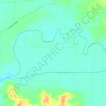
Name: Topografische Karte Patoka River, Höhe, Relief.
Ort: Patoka River, Gibson County, Indiana, United States (38.40036 -87.51207 38.42211 -87.45345)
Durchschnittliche Höhe: 129 m
Minimale Höhe: 118 m
Maximale Höhe: 161 m
Andere topografische Karten
Klicken Sie auf eine Karte, um ihre Topografie, ihre Höhe und ihr Relief anzuzeigen.
Princeton
United States > Indiana > Gibson County
Princeton, Gibson County, Indiana, 47670, United States
Durchschnittliche Höhe: 149 m
Mounts
United States > Indiana > Gibson County
Mounts, Gibson County, Indiana, 47612, United States
Durchschnittliche Höhe: 141 m
East Mount Carmel
United States > Indiana > Gibson County > White River
East Mount Carmel, White River, Gibson County, Indiana, United States
Durchschnittliche Höhe: 122 m
Fort Branch
United States > Indiana > Gibson County > Fort Branch
Fort Branch, Gibson County, Indiana, 47648, United States
Durchschnittliche Höhe: 136 m
Owensville
United States > Indiana > Gibson County
Owensville, Gibson County, Indiana, 47665, United States
Durchschnittliche Höhe: 152 m