Geolokalisieren

Topografische Karte Fornela

Interaktive Karte

Klicken Sie auf die Karte, um die Höhe anzuzeigen.

Über diese Karte

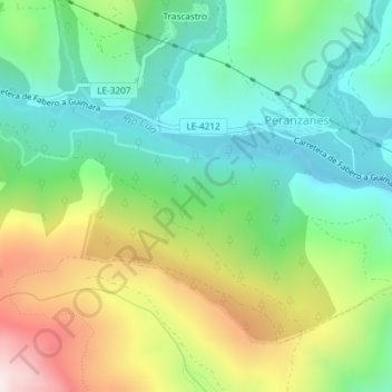
Name: Topografische Karte Fornela, Höhe, Relief.

Ort: Fornela, Peranzanes, El Bierzo, León, Castilla y León, 24429, España (42.86167 -6.65226 42.88167 -6.63226)

Durchschnittliche Höhe: 1.178 m

Minimale Höhe: 894 m

Maximale Höhe: 1.706 m

Andere topografische Karten

Klicken Sie auf eine Karte, um ihre Topografie, ihre Höhe und ihr Relief anzuzeigen.

Guímara

España > Castilla y León > El Bierzo > Peranzanes

Guímara, Peranzanes, El Bierzo, León, Castilla y León, España

Durchschnittliche Höhe: 1.370 m

Fresnedelo

España > Castilla y León > El Bierzo > Peranzanes

Fresnedelo, Peranzanes, El Bierzo, León, Castilla y León, 24429, España

Durchschnittliche Höhe: 1.070 m

Trascastro

España > Castilla y León > El Bierzo > Peranzanes

Trascastro, Peranzanes, El Bierzo, León, Castilla y León, 24429, España

Durchschnittliche Höhe: 1.181 m