
Topografische Karte Middleham
Interaktive Karte
Klicken Sie auf die Karte, um die Höhe anzuzeigen.
Über diese Karte
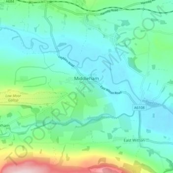
Name: Topografische Karte Middleham, Höhe, Relief.
Ort: Middleham, North Yorkshire, England, United Kingdom (54.27034 -1.86574 54.29837 -1.78292)
Durchschnittliche Höhe: 157 m
Minimale Höhe: 95 m
Maximale Höhe: 378 m
The town lies between 400 and 500 feet (120 and 150 m) above ordnance datum. The valley of the River Ure below the town has an altitude of 325 feet (99 m) and the summit of the hill to the south-west of the town of 850 feet (260 m). The parish contains 2,155 acres (872 ha) of land, mostly permanent pasture with about 150 acres (61 ha) arable. The topsoil is mixed. The valley has modern alluvial terraces and gravel deposits, but the subsoil is mainly limestone, intersected here and there by sandstone with plate. There is a known vein of lead in the northern part of the parish. Braithwaite lead mine lies just outside the parish borders.
Andere topografische Karten
Klicken Sie auf eine Karte, um ihre Topografie, ihre Höhe und ihr Relief anzuzeigen.
Malham
United Kingdom > England > North Yorkshire
Malham, North Yorkshire, England, United Kingdom
Durchschnittliche Höhe: 371 m
Cow Hill
United Kingdom > England > North Yorkshire > Halton West
Cow Hill, Halton West, North Yorkshire, England, BD23 4LP, United Kingdom
Durchschnittliche Höhe: 145 m
Settle
United Kingdom > England > North Yorkshire
Settle, North Yorkshire, England, United Kingdom
Durchschnittliche Höhe: 238 m
Scarborough
United Kingdom > England > North Yorkshire > Scarborough
Scarborough, North Yorkshire, Yorkshire and the Humber, England, United Kingdom
Durchschnittliche Höhe: 50 m