Geolokalisieren
👉 Easily get elevation data in JSON, GeoTIFF and KML formats using Elevation API
Vielen Dank für die Unterstützung dieser Website ❤️
Spenden

Topografische Karte la Vall de Bianya

Klicken Sie auf die Karte, um die Höhe anzuzeigen.

👉 Easily get elevation data in JSON, GeoTIFF and KML formats using Elevation API
Vielen Dank für die Unterstützung dieser Website ❤️
Spenden

Über diese Karte

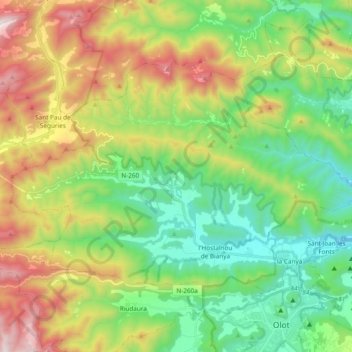
Name: Topografische Karte la Vall de Bianya, Höhe, Relief.

Ort: la Vall de Bianya, Garrotxa, Girona, Catalonia, 17813, Spain (42.19498 2.34311 42.28769 2.53260)

Durchschnittliche Höhe: 722 m

Minimale Höhe: 297 m

Maximale Höhe: 1.492 m

👉 Easily get elevation data in JSON, GeoTIFF and KML formats using Elevation API
Vielen Dank für die Unterstützung dieser Website ❤️
Spenden

Andere topografische Karten

Klicken Sie auf eine Karte, um ihre Topografie, ihre Höhe und ihr Relief anzuzeigen.

Pallerols

Spain > Catalonia > Garrotxa > Sant Feliu de Pallerols

Durchschnittliche Höhe: 608 m

Sant Esteve d'en Bas

Spain > Catalonia > Garrotxa > la Vall d'en Bas

Durchschnittliche Höhe: 560 m

Olot

Spain > Catalonia > Garrotxa > Olot > Olot

Durchschnittliche Höhe: 489 m

Besalú

Spain > Catalonia > Garrotxa > Besalú > Besalú

Durchschnittliche Höhe: 225 m

Vielen Dank für die Unterstützung dieser Website ❤️
Spenden

Begudà

Spain > Catalonia > Garrotxa > Sant Joan les Fonts > Begudà

Durchschnittliche Höhe: 491 m

Beuda

Spain > Catalonia > Garrotxa > Beuda > Beuda

Durchschnittliche Höhe: 460 m