
Vielen Dank für die Unterstützung dieser Website ❤️
Spenden
Spenden
Topografische Karte Tatry
Klicken Sie auf die Karte, um die Höhe anzuzeigen.
Vielen Dank für die Unterstützung dieser Website ❤️
Spenden
Spenden
Tatry
The Tatras lie in the temperate zone of Central Europe. They are an important barrier to the movements of air masses. Their mountainous topography causes one of the most diverse climates in that region.
Vielen Dank für die Unterstützung dieser Website ❤️
Spenden
Spenden
Über diese Karte
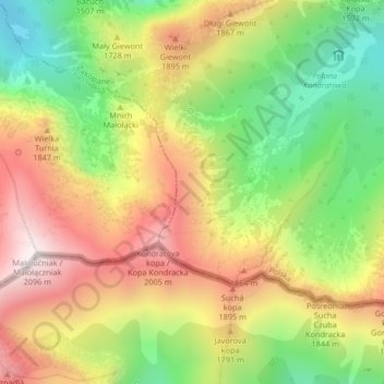
Name: Topografische Karte Tatry, Höhe, Relief.
Durchschnittliche Höhe: 1.647 m
Minimale Höhe: 1.226 m
Maximale Höhe: 2.084 m
Vielen Dank für die Unterstützung dieser Website ❤️
Spenden
Spenden
Andere topografische Karten
Klicken Sie auf eine Karte, um ihre Topografie, ihre Höhe und ihr Relief anzuzeigen.
Czarny Staw Gąsienicowy
Poland > Lesser Poland Voivodeship > Tatra County > Zakopane
Durchschnittliche Höhe: 1.799 m
Czarny Potok
Poland > Lesser Poland Voivodeship > Tatra County > Zakopane
Durchschnittliche Höhe: 869 m