
Topografische Karte Kozhikode
Interaktive Karte
Klicken Sie auf die Karte, um die Höhe anzuzeigen.
Über diese Karte
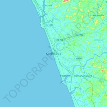
Name: Topografische Karte Kozhikode, Höhe, Relief.
Ort: Kozhikode, Kozhikode district, Kerala, 673001, India (11.08506 75.61547 11.40506 75.93547)
Durchschnittliche Höhe: 14 m
Minimale Höhe: -2 m
Maximale Höhe: 272 m
Andere topografische Karten
Klicken Sie auf eine Karte, um ihre Topografie, ihre Höhe und ihr Relief anzuzeigen.
Vellimadukunnu
India > Kerala > Kozhikode > Kozhikode
Vellimadukunnu, Kozhikode, Kozhikode District, Kerala, India
Durchschnittliche Höhe: 27 m
Mananchira
India > Kerala > Kozhikode > Kozhikode
Mananchira, Palayam, Kozhikode, Kozhikode district, Kerala, India
Durchschnittliche Höhe: 12 m
Chalappuram
India > Kerala > Kozhikode > Kozhikode
Chalappuram, Pathaya Pura, Kozhikode, Kozhikode district, Kerala, India
Durchschnittliche Höhe: 12 m