
Topografische Karte Taoa
Interaktive Karte
Klicken Sie auf die Karte, um die Höhe anzuzeigen.
Über diese Karte
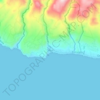
Name: Topografische Karte Taoa, Höhe, Relief.
Ort: Taoa, Alo, Wallis-et-Futuna, 98610, France (-14.32813 -178.14943 -14.28813 -178.10943)
Durchschnittliche Höhe: 87 m
Minimale Höhe: 0 m
Maximale Höhe: 379 m
Andere topografische Karten
Klicken Sie auf eine Karte, um ihre Topografie, ihre Höhe und ihr Relief anzuzeigen.
Tuatafa
France > Wallis-et-Futuna > Alo
Tuatafa, Alo, Wallis-et-Futuna, 98610, France
Durchschnittliche Höhe: 106 m
Mala'e
France > Wallis-et-Futuna > Alo
Mala'e, Alo, Wallis-et-Futuna, 98610, France
Durchschnittliche Höhe: 87 m
Kolia
France > Wallis-et-Futuna > Alo
Kolia, Alo, Wallis-et-Futuna, 98610, France
Durchschnittliche Höhe: 64 m
Olu
France > Wallis-et-Futuna > Alo
Olu, Alo, Wallis-et-Futuna, 98610, France
Durchschnittliche Höhe: 116 m
Alofitai
France > Wallis-et-Futuna > Alo
Alofitai, Alo, Wallis-et-Futuna, 98610, France
Durchschnittliche Höhe: 60 m
Kolopelu
France > Wallis-et-Futuna > Alo
Kolopelu, Alo, Wallis-et-Futuna, 98610, France
Durchschnittliche Höhe: 83 m