Geolokalisieren

Topografische Karte Farm Hills

Interaktive Karte

Klicken Sie auf die Karte, um die Höhe anzuzeigen.

Über diese Karte

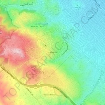
Name: Topografische Karte Farm Hills, Höhe, Relief.

Ort: Farm Hills, Redwood City, San Mateo County, CAL Fire Northern Region, California, 94062, United States (37.43660 -122.27552 37.47660 -122.23552)

Durchschnittliche Höhe: 103 m

Minimale Höhe: 6 m

Maximale Höhe: 263 m

Andere topografische Karten

Klicken Sie auf eine Karte, um ihre Topografie, ihre Höhe und ihr Relief anzuzeigen.

Redwood Shores

United States > California > San Mateo County > Redwood City

Redwood Shores, Redwood City, San Mateo County, CAL Fire Northern Region, California, 94065, United States

Durchschnittliche Höhe: 0 m

Redwood Junction

United States > California > San Mateo County > Redwood City

Redwood Junction, Redwood City, San Mateo County, CAL Fire Northern Region, California, 94063, United States

Durchschnittliche Höhe: 9 m

Redwood City

United States > California > San Mateo County > Redwood City

Redwood City, San Mateo County, California, 94063, United States

Durchschnittliche Höhe: 101 m