
Topografische Karte Brinklow
Interaktive Karte
Klicken Sie auf die Karte, um die Höhe anzuzeigen.
Über diese Karte
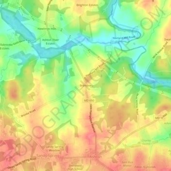
Name: Topografische Karte Brinklow, Höhe, Relief.
Ort: Brinklow, Montgomery County, Maryland, 20862, United States (39.14594 -77.03553 39.18594 -76.99553)
Durchschnittliche Höhe: 126 m
Minimale Höhe: 88 m
Maximale Höhe: 157 m
Andere topografische Karten
Klicken Sie auf eine Karte, um ihre Topografie, ihre Höhe und ihr Relief anzuzeigen.
Rockville
United States > Maryland > Montgomery County
Rockville, Montgomery County, Maryland, United States
Durchschnittliche Höhe: 122 m
Carderock
United States > Maryland > Montgomery County > Potomac
Carderock, Potomac, Montgomery County, Maryland, 20818, United States
Durchschnittliche Höhe: 58 m
Colt Terrace Neighborhood Park
United States > Maryland > Montgomery County > Silver Spring
Colt Terrace Neighborhood Park, 11400, Silver Spring, Montgomery County, Maryland, 20902, United States
Durchschnittliche Höhe: 119 m
Colesville Park
United States > Maryland > Montgomery County > Cloverly
Colesville Park, Cloverly, Montgomery County, Maryland, 20905, United States
Durchschnittliche Höhe: 131 m
Potomac
United States > Maryland > Montgomery County > Potomac
Potomac, Montgomery County, Maryland, 20854, United States
Durchschnittliche Höhe: 86 m
Travilah
United States > Maryland > Montgomery County > Travilah
Travilah, Montgomery County, Maryland, United States
Durchschnittliche Höhe: 96 m
Clarksburg
United States > Maryland > Montgomery County > Clarksburg
Clarksburg, Montgomery County, Maryland, United States
Durchschnittliche Höhe: 167 m
Orchard Place
United States > Maryland > Montgomery County > Gaithersburg
Orchard Place, Gaithersburg, Montgomery County, Maryland, 20899, United States
Durchschnittliche Höhe: 128 m
Woodley Gardens
United States > Maryland > Montgomery County > Rockville
Woodley Gardens, Rockville, Montgomery County, Maryland, 20850, United States
Durchschnittliche Höhe: 134 m
Layhill
United States > Maryland > Montgomery County > Layhill
Layhill, Montgomery County, Maryland, United States
Durchschnittliche Höhe: 112 m
Olney
United States > Maryland > Montgomery County > Olney
Olney, Montgomery County, Maryland, United States
Durchschnittliche Höhe: 136 m
Poolesville
United States > Maryland > Montgomery County
Poolesville, Montgomery County, Maryland, 20837, United States
Durchschnittliche Höhe: 112 m
North Bethesda
United States > Maryland > Montgomery County > North Bethesda
North Bethesda, Montgomery County, Maryland, United States
Durchschnittliche Höhe: 98 m
Cherry Valley
United States > Maryland > Montgomery County > Olney
Cherry Valley, Olney, Montgomery County, Maryland, 20832, United States
Durchschnittliche Höhe: 141 m
Hungerford Towne
United States > Maryland > Montgomery County > Rockville > Hungerford Towne
Hungerford Towne, Rockville, Montgomery County, Maryland, 20852-1601, United States
Durchschnittliche Höhe: 122 m
Clearspring Manor
United States > Maryland > Montgomery County > Damascus > Clearspring Manor
Clearspring Manor, Damascus, Montgomery County, Maryland, 20872, United States
Durchschnittliche Höhe: 215 m
Forest Glen
United States > Maryland > Montgomery County > Forest Glen > McKenney Hills
Forest Glen, McKenney Hills, Forest Glen, Montgomery County, Maryland, 20902-3941, United States
Durchschnittliche Höhe: 105 m
Gaithersburg
United States > Maryland > Montgomery County > Gaithersburg
Gaithersburg, Montgomery County, Maryland, United States
Durchschnittliche Höhe: 137 m
Redland
United States > Maryland > Montgomery County > Redland
Redland, Montgomery County, Maryland, 20855, United States
Durchschnittliche Höhe: 137 m
Bethesda
United States > Maryland > Montgomery County
Bethesda, Montgomery County, Maryland, United States
Durchschnittliche Höhe: 81 m
North Kensington
United States > Maryland > Montgomery County > North Kensington
North Kensington, Montgomery County, Maryland, United States
Durchschnittliche Höhe: 103 m
Silver Spring
United States > Maryland > Montgomery County
Silver Spring, Montgomery County, Maryland, United States
Durchschnittliche Höhe: 86 m
Aspen Hill
United States > Maryland > Montgomery County > Aspen Hill
Aspen Hill, Montgomery County, Maryland, United States
Durchschnittliche Höhe: 117 m